
My saved routes
A collection of 8 cycling routes, created by HPSP.
Overview
About this collection
This collection contains all routes that were previously saved.
- 8
- Routes
- -:--
- Duration
- 253.5 km
- Distance
- ---
- Avg. speed
- 6,787 m
- Ascent
- 8,450 m
- Descent
created this 10 years ago
My saved routes
Routes in this collection
All 8 routes in this collection can be opened on the map or in the Bikemap App for more details, where you can adjust them in the route planner, or download them as GPX or KML file. Use them as a template for planning your own rides, or let Bikemap navigate you along them directly.
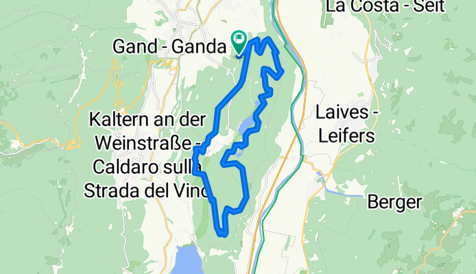
Große Montigglerrunde
Cycling route in Cornaiano, Trentino-Alto Adige, Italy
- 22 km
- Distance
- 413 m
- Ascent
- 413 m
- Descent

Von Auer nach Castelfeder - familienwanderung
- 3.1 km
- Distance
- 155 m
- Ascent
- 155 m
- Descent

Wanderung Rote Wand - Blauer See
- 5.3 km
- Distance
- 127 m
- Ascent
- 127 m
- Descent

Colle 3 A FR
Cycling route in Cardano, Trentino-Alto Adige, Italy
- 24.2 km
- Distance
- 1,040 m
- Ascent
- 1,040 m
- Descent

Eggental-Runde
Cycling route in Cardano, Trentino-Alto Adige, Italy
- 59.6 km
- Distance
- 1,184 m
- Ascent
- 2,008 m
- Descent

Bozen - Titschenklassiker
Cycling route in Cardano, Trentino-Alto Adige, Italy
- 19.5 km
- Distance
- 439 m
- Ascent
- 1,270 m
- Descent

Leifers
Cycling route in Pineta, Trentino-Alto Adige, Italy
- 45.5 km
- Distance
- 1,702 m
- Ascent
- 1,702 m
- Descent

Mendelpaß-Gampenpaß
Cycling route in San Paolo, Trentino-Alto Adige, Italy
- 74.3 km
- Distance
- 1,727 m
- Ascent
- 1,735 m
- Descent