
My saved routes
A collection of 11 cycling routes, created by Daniel K..
Overview
About this collection
This collection contains all routes that were previously saved.
- 11
- Routes
- -:--
- Duration
- 746.8 km
- Distance
- ---
- Avg. speed
- 7,304 m
- Ascent
- 7,302 m
- Descent
created this 9 years ago
My saved routes
Routes in this collection
All 11 routes in this collection can be opened on the map or in the Bikemap App for more details, where you can adjust them in the route planner, or download them as GPX or KML file. Use them as a template for planning your own rides, or let Bikemap navigate you along them directly.

Lenggries - Walchensee - Sylvenstein See
Cycling route in Lenggries, Bavaria, Germany
- 73.8 km
- Distance
- 394 m
- Ascent
- 387 m
- Descent

Spitzingsattel
Cycling route in Gmund am Tegernsee, Bavaria, Germany
- 46.9 km
- Distance
- 719 m
- Ascent
- 725 m
- Descent
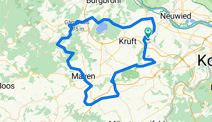
Eifel: Wehr-Polch-Ochtendung
Cycling route in Plaidt, Rhineland-Palatinate, Germany
- 77.8 km
- Distance
- 836 m
- Ascent
- 839 m
- Descent

Westerwald: Bad Marienberg
Cycling route in Plaidt, Rhineland-Palatinate, Germany
- 136 km
- Distance
- 1,028 m
- Ascent
- 1,028 m
- Descent

Westerwald: Bad Ems
Cycling route in Plaidt, Rhineland-Palatinate, Germany
- 83.8 km
- Distance
- 617 m
- Ascent
- 616 m
- Descent

Eifel: Raßberg
Cycling route in Plaidt, Rhineland-Palatinate, Germany
- 79.4 km
- Distance
- 848 m
- Ascent
- 848 m
- Descent

Brohltal: Steinfeld
Cycling route in Plaidt, Rhineland-Palatinate, Germany
- 60.8 km
- Distance
- 597 m
- Ascent
- 597 m
- Descent

Brohl-Laach-Ochtendung
Cycling route in Andernach, Rhineland-Palatinate, Germany
- 48.9 km
- Distance
- 649 m
- Ascent
- 647 m
- Descent

Eifel: Laach - Ochtendung - Rhein CLONED FROM ROUTE 705741
Cycling route in Andernach, Rhineland-Palatinate, Germany
- 63.3 km
- Distance
- 708 m
- Ascent
- 708 m
- Descent
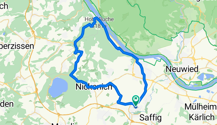
Training: Laacher See
Cycling route in Plaidt, Rhineland-Palatinate, Germany
- 33.9 km
- Distance
- 409 m
- Ascent
- 408 m
- Descent

Pöntner-Brohl-Mendig
Cycling route in Plaidt, Rhineland-Palatinate, Germany
- 42 km
- Distance
- 499 m
- Ascent
- 499 m
- Descent