
My saved routes
A collection of 17 cycling routes, created by Ach_Nee.
Overview
About this collection
This collection contains all routes that were previously saved.
- 17
- Routes
- -:--
- Duration
- 535.6 km
- Distance
- ---
- Avg. speed
- 7,950 m
- Ascent
- 7,859 m
- Descent

created this 9 years ago
My saved routes
Routes in this collection
All 17 routes in this collection can be opened on the map or in the Bikemap App for more details, where you can adjust them in the route planner, or download them as GPX or KML file. Use them as a template for planning your own rides, or let Bikemap navigate you along them directly.
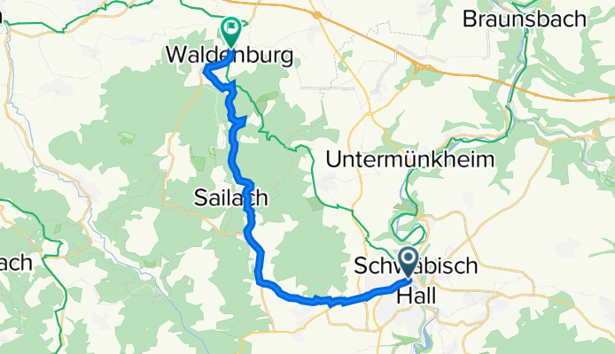
Schwäbisch Hall - Waldenburg - V1
Cycling route in Schwäbisch Hall, Baden-Wurttemberg, Germany
- 17.5 km
- Distance
- 368 m
- Ascent
- 146 m
- Descent

Rund um den Burgberg - Familienrunde
Cycling route in Ilshofen, Baden-Wurttemberg, Germany
- 31.2 km
- Distance
- 185 m
- Ascent
- 183 m
- Descent

Rottal-Radtour
Cycling route in Wüstenrot, Baden-Wurttemberg, Germany
- 38.1 km
- Distance
- 418 m
- Ascent
- 419 m
- Descent

Honkong-Oberrot
Cycling route in Oberrot, Baden-Wurttemberg, Germany
- 38.1 km
- Distance
- 508 m
- Ascent
- 525 m
- Descent

Gaildorf - Altenbergturm
Cycling route in Gaildorf, Baden-Wurttemberg, Germany
- 35.9 km
- Distance
- 525 m
- Ascent
- 528 m
- Descent

Ottersweier Unzhurst Moos
Cycling route in Ottersweier, Baden-Wurttemberg, Germany
- 23.6 km
- Distance
- 64 m
- Ascent
- 64 m
- Descent
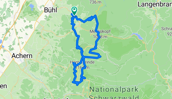
Schwimmbad Bühlertal - Hornisgrinde Rundweg
Cycling route in Bühlertal, Baden-Wurttemberg, Germany
- 44.4 km
- Distance
- 1,131 m
- Ascent
- 1,128 m
- Descent

Sinzheim-Badnerhöhe-Rote Lache-BAD-Sinz
Cycling route in Sinzheim, Baden-Wurttemberg, Germany
- 52.5 km
- Distance
- 1,054 m
- Ascent
- 1,054 m
- Descent

BadenBaden-Batschari-TheRock-YBurg-Lichenttal-BadenBaden
Cycling route in Baden-Baden, Baden-Wurttemberg, Germany
- 17.7 km
- Distance
- 495 m
- Ascent
- 495 m
- Descent

Permanente Bühlertal-Rheintal Tour
Cycling route in Bühlertal, Baden-Wurttemberg, Germany
- 69.8 km
- Distance
- 290 m
- Ascent
- 404 m
- Descent

leichte trainingsloop Sinzheim-Baden-Baden-Rebland
Cycling route in Sinzheim, Baden-Wurttemberg, Germany
- 28 km
- Distance
- 428 m
- Ascent
- 427 m
- Descent

Feierabendtour
Cycling route in Sinzheim, Baden-Wurttemberg, Germany
- 15.2 km
- Distance
- 599 m
- Ascent
- 598 m
- Descent