
My saved routes
A collection of 16 cycling routes, created by sherpabikemap.
Overview
About this collection
This collection contains all routes that were previously saved.
- 16
- Routes
- -:--
- Duration
- 925.1 km
- Distance
- ---
- Avg. speed
- 17,516 m
- Ascent
- 17,556 m
- Descent

created this 9 years ago
My saved routes
Routes in this collection
All 16 routes in this collection can be opened on the map or in the Bikemap App for more details, where you can adjust them in the route planner, or download them as GPX or KML file. Use them as a template for planning your own rides, or let Bikemap navigate you along them directly.

LOMA LINDA-GRANADA-GUEJAR SIERRA-DORNAJO-PURCHE-GRANADA
Cycling route in Gójar, Andalusia, Spain
- 62.1 km
- Distance
- 1,264 m
- Ascent
- 1,335 m
- Descent

IV Trofeo La Giganta
Cycling route in Iznalloz, Andalusia, Spain
- 49.8 km
- Distance
- 1,365 m
- Ascent
- 1,273 m
- Descent

GR222-UItramaraton del Fardes 02/05/09
Cycling route in Granada, Andalusia, Spain
- 117.8 km
- Distance
- 1,866 m
- Ascent
- 1,852 m
- Descent

Sierra de Huetor y Güejar Sierra
Cycling route in Granada, Andalusia, Spain
- 74.7 km
- Distance
- 1,245 m
- Ascent
- 1,287 m
- Descent

Trofeo Giganta Iznalloz 2008 - GR160
Cycling route in Iznalloz, Andalusia, Spain
- 42.7 km
- Distance
- 1,189 m
- Ascent
- 906 m
- Descent

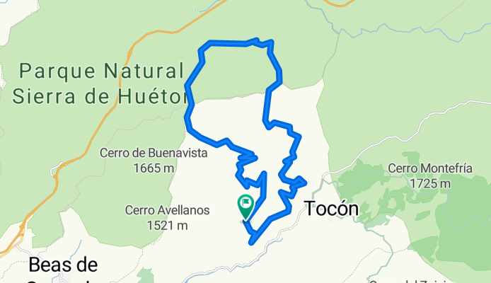
CIRCULAR AGUAS BLANCAS
Cycling route in Beas de Granada, Andalusia, Spain
- 29.1 km
- Distance
- 0 m
- Ascent
- 0 m
- Descent

III quedada mtb lago de andalucia
Cycling route in Iznájar, Andalusia, Spain
- 47.7 km
- Distance
- 991 m
- Ascent
- 991 m
- Descent

23 Curvas-Ermita vieja
Cycling route in Granada, Andalusia, Spain
- 47.2 km
- Distance
- 805 m
- Ascent
- 811 m
- Descent

LOMA LINDA - ALMUÑECAR
Cycling route in Gójar, Andalusia, Spain
- 89.9 km
- Distance
- 1,344 m
- Ascent
- 2,088 m
- Descent

Ruta por Cabo de Gata (II)
- 59.1 km
- Distance
- 685 m
- Ascent
- 685 m
- Descent

LOMA LINDA-FUENTE DEL HERVIDERO-CARTIJUELA-PICO LA CARNE-PURCHE-PINOS GENIL-LOMA LINDA
Cycling route in Ogíjares, Andalusia, Spain
- 74.4 km
- Distance
- 1,342 m
- Ascent
- 1,344 m
- Descent