For your mountain bike
Shred the world’s best mountain bike trails
From rooty forest loops to alpine descents—these are the highest-rated MTB routes shared by riders like you. Get ready to ride.
 Hof - Thalgau - Kolomannsberg - Fuschler Ache - Hof
- Distance
- 33.7 km
- Ascent
- 550 m
- Descent
- 545 m
- Location
- Hof bei Salzburg, Salzburg, Austria
 bike tour through Vegri
- Distance
- 18.7 km
- Ascent
- 647 m
- Descent
- 646 m
- Location
- Valdagno, Veneto, Italy
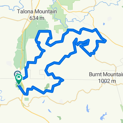 Carns Mill Road ~ Carnes Mill Road
- Distance
- 72 km
- Ascent
- 1,436 m
- Descent
- 1,441 m
- Location
- Jasper, Georgia, United States of America
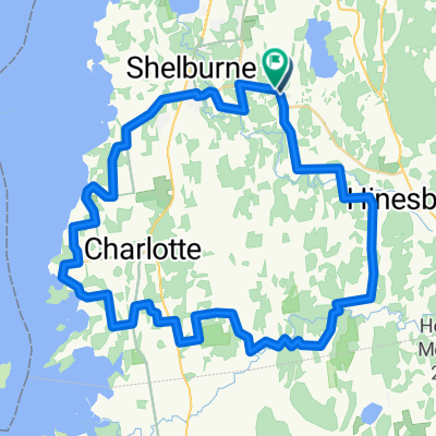 Shelb-Charltt-Philo-Hinesbg
- Distance
- 51.6 km
- Ascent
- 643 m
- Descent
- 645 m
- Location
- Hinesburg, Vermont, United States of America
 Upper Stagecoach Trail, Auburn to Russell Rd, Auburn
- Distance
- 23.4 km
- Ascent
- 962 m
- Descent
- 962 m
- Location
- Auburn, California, United States of America
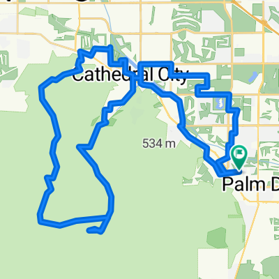 Joshua Rd, Rancho Mirage to Joshua Rd, Rancho Mirage
- Distance
- 60.5 km
- Ascent
- 1,283 m
- Descent
- 1,283 m
- Location
- Rancho Mirage, California, United States of America
 Estancia Piedras Rosadas - Champaqui
- Distance
- 53.8 km
- Ascent
- 1,107 m
- Descent
- 963 m
 PRIMAR PLAZA, PEDRA DO INDIO, INDIANA
- Distance
- 56.2 km
- Ascent
- 682 m
- Descent
- 682 m
- Location
- Botucatu, São Paulo, Brazil
 Jacks and Jollies Pass
- Distance
- 29.5 km
- Ascent
- 769 m
- Descent
- 769 m
 (4h) Qtown / Moke Lake / Arthur-s Point / Qtown
- Distance
- 38.1 km
- Ascent
- 766 m
- Descent
- 778 m
- Location
- Queenstown, Otago, New Zealand
 Otway Estate - Forrest
- Distance
- 70.8 km
- Ascent
- 689 m
- Descent
- 689 m
 Route in Leongatha
- Distance
- 69.1 km
- Ascent
- 572 m
- Descent
- 574 m
 龍門至龍門
龍門至龍門- Distance
- 54.6 km
- Ascent
- 866 m
- Descent
- 866 m
- Location
- Longcheng, Guangdong, China
 16-08-2011郴州(郴州西站)至資興(東江鎮)
- Distance
- 50 km
- Ascent
- 1,024 m
- Descent
- 952 m
- Location
- Chenzhou, Hunan Province, China
 mahidharpura to dumas
- Distance
- 39.4 km
- Ascent
- 750 m
- Descent
- 763 m
- Location
- Surat, Gujarat, India
 7/11/61
- Distance
- 32.2 km
- Ascent
- 1,967 m
- Descent
- 1,963 m
- Location
- Sop Moei, Changwat Mae Hong Son, Thailand
 Day 6 Barafu Camp 4670m to Stella Point 5760m to Uhuru Peak 5895m
- Distance
- 15.6 km
- Ascent
- 1,185 m
- Descent
- 2,744 m
- Location
- Moshi, Kilimanjaro, Tanzania
 De RN2, Ambohipeno imerikiasinina ambatolampikely betdizaraina pedro
- Distance
- 52.6 km
- Ascent
- 2,466 m
- Descent
- 2,507 m
- Location
- Antananarivo, Analamanga Region, Madagascar
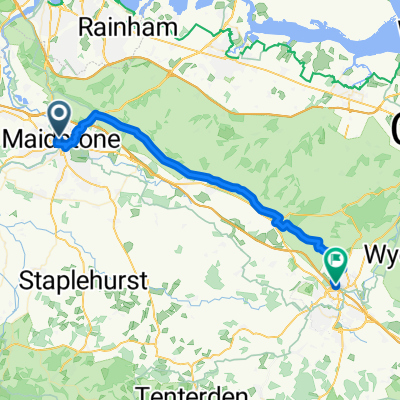 Station Road, Maidstone to M20, Ashford
- Distance
- 38.6 km
- Ascent
- 603 m
- Descent
- 580 m
- Location
- Maidstone, England, United Kingdom
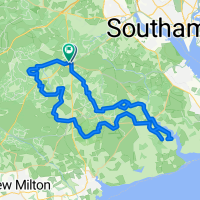 Unnamed Road do High Street
- Distance
- 58.9 km
- Ascent
- 437 m
- Descent
- 434 m
- Location
- Lyndhurst, England, United Kingdom