For your mountain bike
Shred the world’s best mountain bike trails
From rooty forest loops to alpine descents—these are the highest-rated MTB routes shared by riders like you. Get ready to ride.
 Cortina: 5 Rifugi +1
- Distance
- 54 km
- Ascent
- 2,102 m
- Descent
- 2,104 m
- Location
- Cortina d'Ampezzo, Veneto, Italy
 22.6. Tegernsee - Maurach
- Distance
- 52.2 km
- Ascent
- 1,170 m
- Descent
- 972 m
- Location
- Tegernsee, Bavaria, Germany
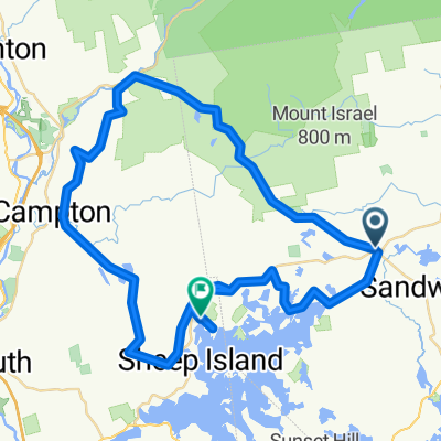 RDC to Center Sandwich to Campton and back over Mt Rd
- Distance
- 73 km
- Ascent
- 1,581 m
- Descent
- 1,595 m
- Location
- Sandwich, New Hampshire, United States of America
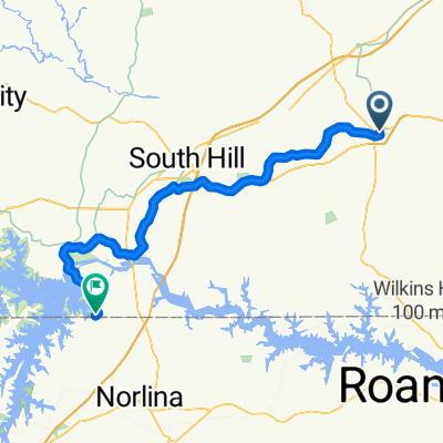 Lawrenceville - Norlina
- Distance
- 68.4 km
- Ascent
- 416 m
- Descent
- 375 m
- Location
- Lawrenceville, Virginia, United States of America
 Foresthill Ave, Auburn to Foresthill Ave, Auburn
- Distance
- 22.7 km
- Ascent
- 1,002 m
- Descent
- 1,004 m
- Location
- Auburn, California, United States of America
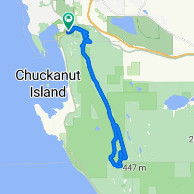 Route in Bellingham
- Distance
- 19.5 km
- Ascent
- 832 m
- Descent
- 832 m
- Location
- Bellingham, Washington, United States of America
 Diamantina-Barão de Gauicuy-12maio2013
- Distance
- 49.3 km
- Ascent
- 1,428 m
- Descent
- 1,430 m
- Location
- Diamantina, Minas Gerais, Brazil
 CAMPEONATO ARGENTINO COPA XC CABLE CARRIL 2015
- Distance
- 42.7 km
- Ascent
- 427 m
- Descent
- 422 m
- Location
- Chilecito, La Rioja Province, Argentina
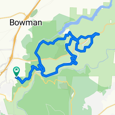
 Jacks and Jollies Pass
- Distance
- 29.5 km
- Ascent
- 769 m
- Descent
- 769 m
 J'ville - Ohairu - Spicer Forest - Return Loop
- Distance
- 23.9 km
- Ascent
- 530 m
- Descent
- 528 m
- Location
- Petone, Wellington, New Zealand
 45 Norman Fisher Cct - Downard Street Calwell - rel 2
- Distance
- 37.8 km
- Ascent
- 540 m
- Descent
- 523 m
- Location
- Kaleen, Australian Capital Territory, Australia
 Bike SA Outback Odyssey Day 2
- Distance
- 74 km
- Ascent
- 471 m
- Descent
- 610 m
- Location
- Lobethal, South Australia, Australia
 16-08-2011郴州(郴州西站)至資興(東江鎮)
- Distance
- 50 km
- Ascent
- 1,024 m
- Descent
- 952 m
- Location
- Chenzhou, Hunan Province, China
 장태산 오동임도
- Distance
- 46.2 km
- Ascent
- 417 m
- Descent
- 404 m
- Location
- Daejeon, Daejeon, Republic of Korea
 Jhaputar - Sanghe - Dulepani - Kalesti - Damauli- Jhaputar
- Distance
- 37.8 km
- Ascent
- 936 m
- Descent
- 948 m
 Tag 8: Wadi Bani Awf
- Distance
- 53.7 km
- Ascent
- 1,447 m
- Descent
- 2,091 m
- Location
- Bahlā’, Muḩāfaz̧at ad Dākhilīyah, Oman
 Klapmuts - Hermon via Ou Koei
- Distance
- 68.5 km
- Ascent
- 4,585 m
- Descent
- 4,562 m
- Location
- Paarl, Province of the Western Cape, Republic of South Africa
 De bypass ambohimalaza nandizakely carion angavokely ambanitsena ambatolampy kely betsizaraina ambohimahitsy
- Distance
- 67.4 km
- Ascent
- 1,734 m
- Descent
- 1,774 m
- Location
- Antananarivo, Analamanga Region, Madagascar
 plan purley
- Distance
- 33.7 km
- Ascent
- 459 m
- Descent
- 455 m
- Location
- Purley, England, United Kingdom
 Epsom Downs and Headly loop
- Distance
- 21.8 km
- Ascent
- 410 m
- Descent
- 408 m
- Location
- Ashtead, England, United Kingdom