
Cycling in Sungguminasa
Discover a map of 133 cycling routes and bike trails near Sungguminasa, created by our community.
Region portrait
Get to know Sungguminasa
Find the right bike route for you through Sungguminasa, where we've got 133 cycle routes to explore. Most people get on their bikes to ride here in the months of August and September.
2,470 km
Tracked distance
133
Cycle routes
Community
Most active users in Sungguminasa


From our community
The best bike routes in and around Sungguminasa


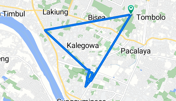
Gowes Gowa
Cycling route in Sungguminasa, South Sulawesi, Indonesia
- 10.6 km
- Distance
- 12 m
- Ascent
- 9 m
- Descent


Ko. Bumi Bung Permai A.3/6, Kecamatan Tamalanrea to Ko. Bumi Bung Permai A.3/6, Kecamatan Tamalanrea
Cycling route in Sungguminasa, South Sulawesi, Indonesia
- 10.2 km
- Distance
- 105 m
- Ascent
- 82 m
- Descent
![[LT] Citraland TAR - Jungle Camp (II)](https://media.bikemap.net/routes/9506427/staticmaps/in_84506b2e-4af3-44ad-8ac7-1332f1ac2f10_694x400_bikemap-2021-3D-static.png)
[LT] Citraland TAR - Jungle Camp (II)
Cycling route in Sungguminasa, South Sulawesi, Indonesia
- 42 km
- Distance
- 207 m
- Ascent
- 206 m
- Descent
Recovered Route
Cycling route in Sungguminasa, South Sulawesi, Indonesia
- 6.4 km
- Distance
- 17 m
- Ascent
- 16 m
- Descent
Discover more routes
![[LT] Hertasning Football Field](https://media.bikemap.net/routes/9444349/staticmaps/in_3ca7a6b1-50af-42f7-9577-24a5df649bc8_400x400_bikemap-2021-3D-static.png) [LT] Hertasning Football Field
[LT] Hertasning Football Field- Distance
- 19.7 km
- Ascent
- 42 m
- Descent
- 44 m
- Location
- Sungguminasa, South Sulawesi, Indonesia
 Jalan Daeng Hayo NO.4, Komp.perh.laut Kecamatan Manggala to Jalan Daeng Hayo 52, Kecamatan Manggala
- Distance
- 24 km
- Ascent
- 89 m
- Descent
- 112 m
- Location
- Sungguminasa, South Sulawesi, Indonesia
 Romang Lompoa, Bontomarannu to Jalan Lamputang 16a, Kecamatan Bontoala
- Distance
- 16 km
- Ascent
- 92 m
- Descent
- 39 m
- Location
- Sungguminasa, South Sulawesi, Indonesia
 bike tour through jenneberang
- Distance
- 13 km
- Ascent
- 15 m
- Descent
- 18 m
- Location
- Sungguminasa, South Sulawesi, Indonesia
 Jalan Budaya 29, Kecamatan Pallangga to Jalan Budaya 28, Kecamatan Pallangga
- Distance
- 11.1 km
- Ascent
- 45 m
- Descent
- 58 m
- Location
- Sungguminasa, South Sulawesi, Indonesia
 Jalan K. H. Wahid Hasyim 26, Kecamatan Somba Opu to Jalan Hartaco Blok.iv Ac 1, Kecamatan Tamalate
- Distance
- 73.8 km
- Ascent
- 648 m
- Descent
- 651 m
- Location
- Sungguminasa, South Sulawesi, Indonesia
 Pakatto FFG Cendekia, Bontomarannu to PGRG+8HR, Bontomarannu
- Distance
- 7.9 km
- Ascent
- 14 m
- Descent
- 54 m
- Location
- Sungguminasa, South Sulawesi, Indonesia
 sore2
sore2- Distance
- 24 km
- Ascent
- 526 m
- Descent
- 527 m
- Location
- Sungguminasa, South Sulawesi, Indonesia