
Cycling in Takefu
Discover a map of 39 cycling routes and bike trails near Takefu, created by our community.
Region portrait
Get to know Takefu
Find the right bike route for you through Takefu, where we've got 39 cycle routes to explore. Most people get on their bikes to ride here in the month of May.
920 km
Tracked distance
39
Cycle routes
75,753
Population
Community
Most active users in Takefu


From our community
The best bike routes in and around Takefu


De 13-18, Hiraide 2-Chōme, Echizen a 1-10, Hiraide 2-Chōme, Echizen
Cycling route in Takefu, Fukui, Japan
- 3.5 km
- Distance
- 27 m
- Ascent
- 25 m
- Descent
De 3-22, Hiraide 2-Chōme, Echizen a 13-18, Hiraide 2-Chōme, Echizen
Cycling route in Takefu, Fukui, Japan
- 4.2 km
- Distance
- 20 m
- Ascent
- 16 m
- Descent

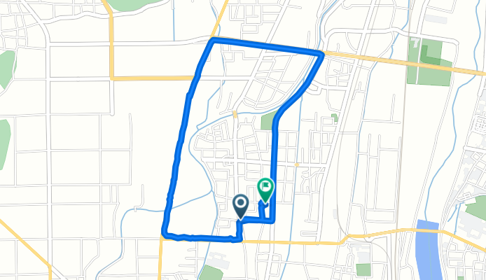
De 3-16, Motomachi, Echizen a 1-6, Wakamatsucho, Echizen
Cycling route in Takefu, Fukui, Japan
- 20.7 km
- Distance
- 34 m
- Ascent
- 56 m
- Descent
Discover more routes
 imajou-tsuruga
- Distance
- 30.6 km
- Ascent
- 1,007 m
- Descent
- 1,124 m
- Location
- Takefu, Fukui, Japan
 福井武生車站往池田町Tree Picnic Adventure Ikeda
- Distance
- 22.1 km
- Ascent
- 512 m
- Descent
- 260 m
- Location
- Takefu, Fukui, Japan
 De 22-7, Echizen a 23-15, Echizen
- Distance
- 7.2 km
- Ascent
- 71 m
- Descent
- 72 m
- Location
- Takefu, Fukui, Japan
 echizen Awara
- Distance
- 42.1 km
- Ascent
- 326 m
- Descent
- 353 m
- Location
- Takefu, Fukui, Japan
 May 2. 58-9-1, Umeura, Echizen, Nyu-Gun to Shiohamamachi, Kaga
- Distance
- 64.3 km
- Ascent
- 875 m
- Descent
- 868 m
- Location
- Takefu, Fukui, Japan
 De 県道19号, Echizen-Shi a 187, Sawacho, Echizen-Shi
- Distance
- 10 km
- Ascent
- 130 m
- Descent
- 134 m
- Location
- Takefu, Fukui, Japan
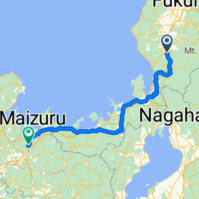 Takefu - Maizuru
- Distance
- 136.7 km
- Ascent
- 60 m
- Descent
- 32 m
- Location
- Takefu, Fukui, Japan
 10 丹南ふれあいスポーツレクリェーションロード
- Distance
- 26.1 km
- Ascent
- 59 m
- Descent
- 159 m
- Location
- Takefu, Fukui, Japan