
Cycling in Handa
Discover a map of 31 cycling routes and bike trails near Handa, created by our community.
Region portrait
Get to know Handa
Find the right bike route for you through Handa, where we've got 31 cycle routes to explore. Most people get on their bikes to ride here in the month of March.
458 km
Tracked distance
31
Cycle routes
116,119
Population
Community
Most active users in Handa


From our community
The best bike routes in and around Handa

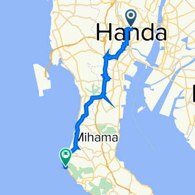
Sumiyoshicho to Takahamaminato
Cycling route in Handa, Aichi, Japan
- 7.2 km
- Distance
- 20 m
- Ascent
- 17 m
- Descent


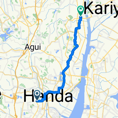
De 5-chōme, Handa a 1-chōme, Handa
Cycling route in Handa, Aichi, Japan
- 32 km
- Distance
- 186 m
- Ascent
- 180 m
- Descent

1_3_HANDA_GAMAGORI_38km_270m
Cycling route in Handa, Aichi, Japan
- 37.2 km
- Distance
- 179 m
- Ascent
- 186 m
- Descent
Discover more routes
 1-chōme, Handa to Asahi 10, Higashiura
- Distance
- 13.2 km
- Ascent
- 76 m
- Descent
- 83 m
- Location
- Handa, Aichi, Japan
 201-31, Hiiragicho 4-Chōme, Handa to Minamichita Road, Taketoyo, Chita-Gun
- Distance
- 8.7 km
- Ascent
- 213 m
- Descent
- 211 m
- Location
- Handa, Aichi, Japan
 3丁目, 半田市 まで2, 四日市市
- Distance
- 81.8 km
- Ascent
- 237 m
- Descent
- 242 m
- Location
- Handa, Aichi, Japan
 De 1-chōme, Handa a 1-chōme, Handa
- Distance
- 1.4 km
- Ascent
- 3 m
- Descent
- 0 m
- Location
- Handa, Aichi, Japan
 Recovered Route
- Distance
- 26.1 km
- Ascent
- 186 m
- Descent
- 215 m
- Location
- Handa, Aichi, Japan
 De Miyahiraike, Agui a 1-chōme, Handa
- Distance
- 3.3 km
- Ascent
- 23 m
- Descent
- 21 m
- Location
- Handa, Aichi, Japan
 ②玉福稲荷
②玉福稲荷- Distance
- 7.3 km
- Ascent
- 54 m
- Descent
- 59 m
- Location
- Handa, Aichi, Japan
 De 7-chōme, Handa a 1-chōme, Handa
- Distance
- 0.7 km
- Ascent
- 0 m
- Descent
- 24 m
- Location
- Handa, Aichi, Japan