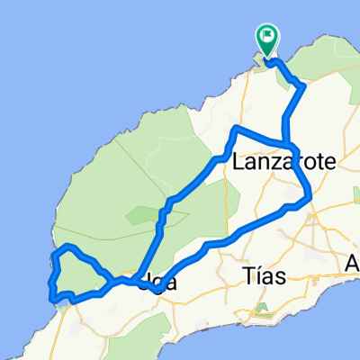
Cycling in Tinajo
Discover a map of 168 cycling routes and bike trails near Tinajo, created by our community.
Region portrait
Get to know Tinajo
Find the right bike route for you through Tinajo, where we've got 168 cycle routes to explore. Most people get on their bikes to ride here in the months of January and March.
9,800 km
Tracked distance
168
Cycle routes
5,228
Population
Community
Most active users in Tinajo
Handpicked routes
Discover Tinajo through these collections

Tour
Tour
From our community
The best bike routes in and around Tinajo
MTB-Tour "Vulkane und Lava"
Cycling route in Tinajo, Canary Islands, Spain
Ausgangspunkt der Tour ist der Parkplatz oberhalb von Tinguaton an der LZ 56. Am Ende des Fahrweges beginnt der moderate Aufstieg auf den 456 m hohen Rodeos, der in einem steilen Anstieg auf den Gipfel endet. Die Mühe lohnt sich, der Rundumblick ist überwältigend. Am Fuße des Rodeos durchqueren wir ein Lavafeld, überqueren die LZ 56 und umrunden den Montana Negra. Quer durch Weinanbau erreichen wir La Florida, ein Besuch des ältesten Weingutes Lanzarotes "El Grifo" mit integriertem Weinmuseum an der LZ 30 lohnt sich. Zurück nach La Florida durchqueren wir ein weiteres Lavafeld und Weinanbau. Die Tour führt an einer begehbaren Höhle im Lavagstein vorbei mit anschließender Umrundung der beiden Vulkane Colorada und Caldera Colorada. Infotafeln am Weg informieren über die verschiedenen Formen des Vulkanismus in dieser Gegend. Die 50 t-schwere Steinbombe aus dem Caldera Colorada geschläudert, ist nicht zu übersehen (s.Bild).
Anmerkung: Die Fahrt durch die unterschiedlichen Lavafelder erfordert erhöhte Aufmerksamkeit und eine sichere Fahrtechnik.
- 30.6 km
- Distance
- 262 m
- Ascent
- 258 m
- Descent
IRONMAN 70.3 Lanzarote - Bikesplit <> 2012-11-10
Cycling route in Tinajo, Canary Islands, Spain
- 89.5 km
- Distance
- 1,089 m
- Ascent
- 1,088 m
- Descent
Big loop Lanza
Cycling route in Tinajo, Canary Islands, Spain
- 159.7 km
- Distance
- 1,600 m
- Ascent
- 1,598 m
- Descent
La Santa - Yaiza
Cycling route in Tinajo, Canary Islands, Spain
- 56.6 km
- Distance
- 577 m
- Ascent
- 579 m
- Descent
Discover more routes
- La Santa ascending Los Valles and Tabayesco
- Distance
- 91.2 km
- Ascent
- 1,391 m
- Descent
- 1,385 m
- Location
- Tinajo, Canary Islands, Spain
- Nationalpark Timanfaya (Feuerberge)
- Distance
- 56 km
- Ascent
- 589 m
- Descent
- 589 m
- Location
- Tinajo, Canary Islands, Spain
- Lanzarote Giorno 2
- Distance
- 114.6 km
- Ascent
- 1,445 m
- Descent
- 1,449 m
- Location
- Tinajo, Canary Islands, Spain
- Conil Trip - Distance 50km
- Distance
- 52.2 km
- Ascent
- 415 m
- Descent
- 415 m
- Location
- Tinajo, Canary Islands, Spain
- Nationalpark Timanfaya (Feuerberge)
- Distance
- 56 km
- Ascent
- 594 m
- Descent
- 597 m
- Location
- Tinajo, Canary Islands, Spain
- Einstiegsroute Lanza
- Distance
- 44.2 km
- Ascent
- 418 m
- Descent
- 418 m
- Location
- Tinajo, Canary Islands, Spain
- La Santa-TiAqua-Tinajo-LaSanta
- Distance
- 21.1 km
- Ascent
- 222 m
- Descent
- 223 m
- Location
- Tinajo, Canary Islands, Spain
- Kleine Runde auf Lanzarote
- Distance
- 41.6 km
- Ascent
- 458 m
- Descent
- 384 m
- Location
- Tinajo, Canary Islands, Spain