
Cycling in Shepherdswell
Discover a map of 54 cycling routes and bike trails near Shepherdswell, created by our community.
Region portrait
Get to know Shepherdswell
Find the right bike route for you through Shepherdswell, where we've got 54 cycle routes to explore. Most people get on their bikes to ride here in the month of May.
1,364 km
Tracked distance
54
Cycle routes
1,576
Population
Community
Most active users in Shepherdswell

From our community
The best bike routes in and around Shepherdswell

Steady ride in Canterbury
Cycling route in Shepherdswell, England, United Kingdom
- 19.9 km
- Distance
- 217 m
- Ascent
- 267 m
- Descent


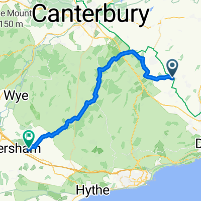
Bike to Grandma’s
Cycling route in Shepherdswell, England, United Kingdom
- 165.9 km
- Distance
- 792 m
- Ascent
- 871 m
- Descent

Church Whitfield Road, Waldershare, Dover to Barfrestone Road, Barfrestone, Dover
Cycling route in Shepherdswell, England, United Kingdom
- 8.9 km
- Distance
- 109 m
- Ascent
- 139 m
- Descent
Discover more routes
 fred
fred- Distance
- 75.5 km
- Ascent
- 286 m
- Descent
- 285 m
- Location
- Shepherdswell, England, United Kingdom
 Dover1
- Distance
- 12.4 km
- Ascent
- 96 m
- Descent
- 205 m
- Location
- Shepherdswell, England, United Kingdom
 1–35 The Crescent, Snowdown, Dover to 1–35 The Crescent, Snowdown, Dover
- Distance
- 55.7 km
- Ascent
- 736 m
- Descent
- 737 m
- Location
- Shepherdswell, England, United Kingdom
 Dover2
- Distance
- 10.2 km
- Ascent
- 47 m
- Descent
- 156 m
- Location
- Shepherdswell, England, United Kingdom
 smeeth
- Distance
- 31.6 km
- Ascent
- 419 m
- Descent
- 397 m
- Location
- Shepherdswell, England, United Kingdom
 sandwich
- Distance
- 58.3 km
- Ascent
- 359 m
- Descent
- 358 m
- Location
- Shepherdswell, England, United Kingdom
 sandwichdeal
- Distance
- 71.8 km
- Ascent
- 442 m
- Descent
- 445 m
- Location
- Shepherdswell, England, United Kingdom
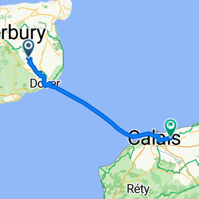 Shepherdswell - Marck
- Distance
- 68.1 km
- Ascent
- 165 m
- Descent
- 232 m
- Location
- Shepherdswell, England, United Kingdom