
Cycling in Martham
Discover a map of 71 cycling routes and bike trails near Martham, created by our community.
Region portrait
Get to know Martham
Find the right bike route for you through Martham, where we've got 71 cycle routes to explore. Most people get on their bikes to ride here in the months of August and September.
1,518 km
Tracked distance
71
Cycle routes
3,089
Population
Community
Most active users in Martham


From our community
The best bike routes in and around Martham

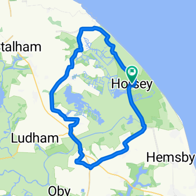
Horsey Circular
Cycling route in Martham, England, United Kingdom
Horsey Circular as featured in The Broads By Bike booklet.
This booklet is available from Tourist Information Centres in the area or at www.thebroadsbybike.org.uk
- 32.4 km
- Distance
- 52 m
- Ascent
- 53 m
- Descent

Waxham Sands to Rose Tavern with detour to George Borrow Road
Cycling route in Martham, England, United Kingdom
Pleasant route.
Once you leave the coast road there are few cars until you come into Norwich on the Spixworth Road.
- 47.7 km
- Distance
- 106 m
- Ascent
- 79 m
- Descent

Ludham circuit 29/7
Cycling route in Martham, England, United Kingdom
- 29.9 km
- Distance
- 46 m
- Ascent
- 43 m
- Descent

Discover more routes
 Horsey 5.25 miles
- Distance
- 8.4 km
- Ascent
- 0 m
- Descent
- 0 m
- Location
- Martham, England, United Kingdom
 Waxham Sands to Sugar'n Spice Café at Bacton and return
- Distance
- 52.9 km
- Ascent
- 121 m
- Descent
- 121 m
- Location
- Martham, England, United Kingdom
 Recovered Route
- Distance
- 35.3 km
- Ascent
- 85 m
- Descent
- 83 m
- Location
- Martham, England, United Kingdom
 Unnamed Road to Norwich. forgot to end trip.
- Distance
- 84.9 km
- Ascent
- 303 m
- Descent
- 282 m
- Location
- Martham, England, United Kingdom
 Horsey, Great Yarmouth to 41 Trinity St, Norwich
- Distance
- 48.3 km
- Ascent
- 209 m
- Descent
- 181 m
- Location
- Martham, England, United Kingdom
 Hall Cottages 2, Horsey to Hall Cottages 2, Horsey
- Distance
- 31.3 km
- Ascent
- 59 m
- Descent
- 60 m
- Location
- Martham, England, United Kingdom
 Village route
- Distance
- 17.5 km
- Ascent
- 52 m
- Descent
- 49 m
- Location
- Martham, England, United Kingdom
 Horning
- Distance
- 23.1 km
- Ascent
- 29 m
- Descent
- 21 m
- Location
- Martham, England, United Kingdom