
Cycling in Ceres
Discover a map of 14 cycling routes and bike trails near Ceres, created by our community.
Region portrait
Get to know Ceres
Find the right bike route for you through Ceres, where we've got 14 cycle routes to explore.
458 km
Tracked distance
14
Cycle routes
1,023
Population
Community
Most active users in Ceres


Handpicked routes
Discover Ceres through these collections
Tour
From our community
The best bike routes in and around Ceres

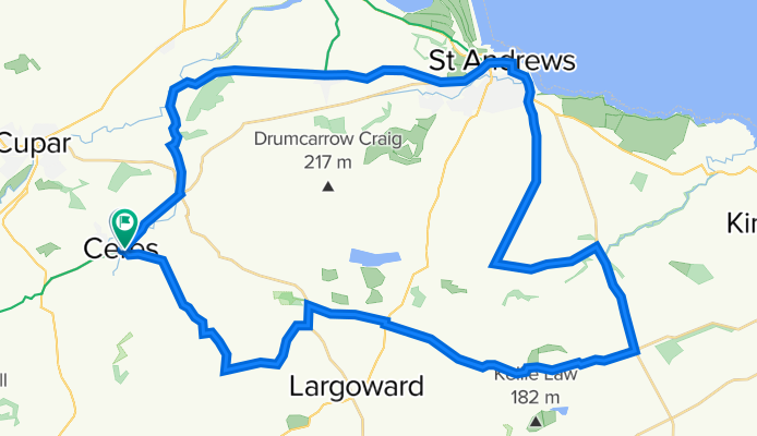
Ceres - St Andrews - Peat Inn circular
Cycling route in Ceres, Scotland, United Kingdom
Start from the car park in Ceres (cafe adjacent), head to Pitscottie and tuke the downhill rin through Dura Den. From the bottom,back uphill to Strathkinnes and St Andrews. The return route avoids major roads apart from a short stretch along B1931. From New Gilston there is a fast descent into Ceres. All on good road.
- 46.7 km
- Distance
- 393 m
- Ascent
- 392 m
- Descent


Ceres - Falkland - Auchtermuchty - Ladybank - Cupar
Cycling route in Ceres, Scotland, United Kingdom
Start from the car park in Ceres (cafe adjacent) and head for Chance Inn and further south east, eventually turning west and out of the hills for the run to Falkland. From there, across the Howe of Fife and a short excursion into the north Fife hills before heading for Ladybank. A short stretch of gravel track is used in the next section to Cupar and return uphill to Ceres.
- 52.8 km
- Distance
- 355 m
- Ascent
- 355 m
- Descent

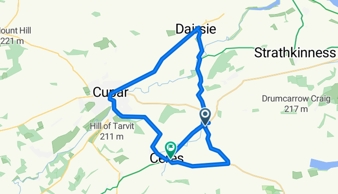
Ceres - Falkland - Newburgh - Cupar
Cycling route in Ceres, Scotland, United Kingdom
Uses routes NCN1, 776, 777, then C road to Cupar and on to Ceres, the start point
- 57.4 km
- Distance
- 650 m
- Ascent
- 648 m
- Descent
peat inn hill route 1
Cycling route in Ceres, Scotland, United Kingdom
half way up to pet inn then back to ceres
- 33.7 km
- Distance
- 327 m
- Ascent
- 303 m
- Descent
Discover more routes
 ceres route
- Distance
- 19.2 km
- Ascent
- 158 m
- Descent
- 145 m
- Location
- Ceres, Scotland, United Kingdom
 B941, Cupar to Abbey Park Avenue, St Andrews
- Distance
- 22.4 km
- Ascent
- 166 m
- Descent
- 336 m
- Location
- Ceres, Scotland, United Kingdom
 Ceres - Pittenweem - Anstruther loop
- Distance
- 54.9 km
- Ascent
- 431 m
- Descent
- 432 m
- Location
- Ceres, Scotland, United Kingdom
 Burnbank Garage, Cupar Road, Cupar to Clayton, St Andrews
- Distance
- 6.6 km
- Ascent
- 69 m
- Descent
- 100 m
- Location
- Ceres, Scotland, United Kingdom
 Old Hall, Cupar to Hillview, Ceres Road, Cupar
- Distance
- 8.4 km
- Ascent
- 73 m
- Descent
- 190 m
- Location
- Ceres, Scotland, United Kingdom
 Collierfield House, Cupar to East Neuk and Landward Ward, Fife
- Distance
- 18.8 km
- Ascent
- 78 m
- Descent
- 243 m
- Location
- Ceres, Scotland, United Kingdom
 B941, Cupar to 10 South Bridge, Cupar
- Distance
- 11.5 km
- Ascent
- 45 m
- Descent
- 217 m
- Location
- Ceres, Scotland, United Kingdom
 Ceres - Tay shore - Tentsmuir - Leuchars
- Distance
- 65.4 km
- Ascent
- 445 m
- Descent
- 446 m
- Location
- Ceres, Scotland, United Kingdom