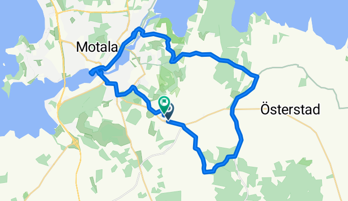
Cycling in Stenstorp
Discover a map of 13 cycling routes and bike trails near Stenstorp, created by our community.
Region portrait
Get to know Stenstorp
Find the right bike route for you through Stenstorp, where we've got 13 cycle routes to explore.
523 km
Tracked distance
13
Cycle routes
1,630
Population
Community
Most active users in Stenstorp
From our community
The best bike routes in and around Stenstorp
Västra Stenby 126, Motala to Norra Sjövägen, Ödeshög
Cycling route in Stenstorp, Östergötland County, Sweden
- 36.5 km
- Distance
- 371 m
- Ascent
- 326 m
- Descent
Norrsten to MĂĄsgatan 5
Cycling route in Stenstorp, Östergötland County, Sweden
- 11.3 km
- Distance
- 49 m
- Ascent
- 42 m
- Descent
Vatternrundan 2016
Cycling route in Stenstorp, Östergötland County, Sweden
- 289.7 km
- Distance
- 515 m
- Ascent
- 537 m
- Descent
helena3
Cycling route in Stenstorp, Östergötland County, Sweden
- 45.5 km
- Distance
- 111 m
- Ascent
- 188 m
- Descent
Discover more routes
- skänninge station
- Distance
- 11.4 km
- Ascent
- 61 m
- Descent
- 84 m
- Location
- Stenstorp, Östergötland County, Sweden
- Ă–stervarv to Motala station
- Distance
- 11.7 km
- Ascent
- 99 m
- Descent
- 122 m
- Location
- Stenstorp, Östergötland County, Sweden
- Norrsten to Platensgatan 2A
- Distance
- 6.2 km
- Ascent
- 57 m
- Descent
- 67 m
- Location
- Stenstorp, Östergötland County, Sweden
- Varby vägskäl to Vinnerstad
- Distance
- 0.9 km
- Ascent
- 7 m
- Descent
- 3 m
- Location
- Stenstorp, Östergötland County, Sweden
- Ă–stervarv to Ask
- Distance
- 5.1 km
- Ascent
- 43 m
- Descent
- 70 m
- Location
- Stenstorp, Östergötland County, Sweden
- Tranberga, Motala to Styra, Motala
- Distance
- 1.4 km
- Ascent
- 3 m
- Descent
- 3 m
- Location
- Stenstorp, Östergötland County, Sweden
- Stenstorp Cycling
- Distance
- 71.3 km
- Ascent
- 338 m
- Descent
- 334 m
- Location
- Stenstorp, Östergötland County, Sweden
- Recovered Route
- Distance
- 18 km
- Ascent
- 163 m
- Descent
- 193 m
- Location
- Stenstorp, Östergötland County, Sweden