
Cycling in Kolbäck
Discover a map of 32 cycling routes and bike trails near Kolbäck, created by our community.
Region portrait
Get to know Kolbäck
Find the right bike route for you through Kolbäck, where we've got 32 cycle routes to explore. Most people get on their bikes to ride here in the month of July.
1,486 km
Tracked distance
32
Cycle routes
1,853
Population
Community
Most active users in Kolbäck


From our community
The best bike routes in and around Kolbäck
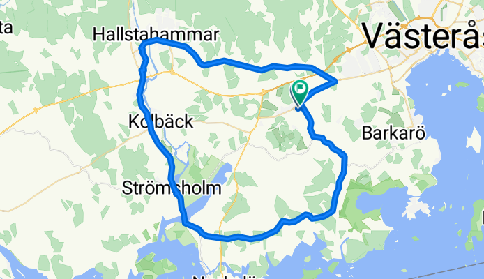
Albertusvägen, Västerås to Ekebyvägen, Västerås
Cycling route in Kolbäck, Västmanland County, Sweden
- 50.3 km
- Distance
- 192 m
- Ascent
- 197 m
- Descent
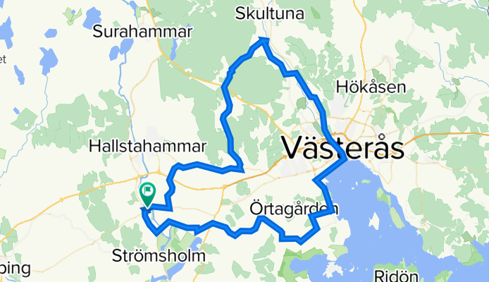
Tingshusgatan 21 to Tingshusgatan 21
Cycling route in Kolbäck, Västmanland County, Sweden
- 75.4 km
- Distance
- 413 m
- Ascent
- 416 m
- Descent

SC 0200-0250
Cycling route in Kolbäck, Västmanland County, Sweden
- 50 km
- Distance
- 173 m
- Ascent
- 148 m
- Descent

Kolbäck-Julita
Cycling route in Kolbäck, Västmanland County, Sweden
- 66 km
- Distance
- 201 m
- Ascent
- 186 m
- Descent
Discover more routes
 ECT2020 Mälaren norra
- Distance
- 145.5 km
- Ascent
- 240 m
- Descent
- 241 m
- Location
- Kolbäck, Västmanland County, Sweden
 ECT2020-T22 MälarenRunt Dag 2
- Distance
- 157.5 km
- Ascent
- 1,216 m
- Descent
- 1,200 m
- Location
- Kolbäck, Västmanland County, Sweden
 UTNÄS 11 to Valskogsvägen 70
- Distance
- 29.9 km
- Ascent
- 139 m
- Descent
- 139 m
- Location
- Kolbäck, Västmanland County, Sweden
 Albertusvägen, Västerås to Albertusvägen, Västerås
- Distance
- 32 km
- Ascent
- 104 m
- Descent
- 108 m
- Location
- Kolbäck, Västmanland County, Sweden
 Stationsgatan 12A, Kolbäck nach Hökartorget 2, Köping
- Distance
- 15.8 km
- Ascent
- 73 m
- Descent
- 74 m
- Location
- Kolbäck, Västmanland County, Sweden
 Oskarsborgsvägen 37, Strömsholm to Oskarsborgsvägen 37, Strömsholm
- Distance
- 11.9 km
- Ascent
- 135 m
- Descent
- 133 m
- Location
- Kolbäck, Västmanland County, Sweden
 Eriksbergsvägen 7–9, Hallstahammar to Västtunagatan 7, Hallstahammar
- Distance
- 4.1 km
- Ascent
- 16 m
- Descent
- 0 m
- Location
- Kolbäck, Västmanland County, Sweden
 Dag 2
Dag 2- Distance
- 134.8 km
- Ascent
- 430 m
- Descent
- 390 m
- Location
- Kolbäck, Västmanland County, Sweden