
Cycling in Nestelbach bei Graz
Discover a map of 174 cycling routes and bike trails near Nestelbach bei Graz, created by our community.
Region portrait
Get to know Nestelbach bei Graz
Find the right bike route for you through Nestelbach bei Graz, where we've got 174 cycle routes to explore. Most people get on their bikes to ride here in the months of May and June.
11,840 km
Tracked distance
174
Cycle routes
Community
Most active users in Nestelbach bei Graz


From our community
The best bike routes in and around Nestelbach bei Graz

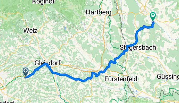
Nestelbach - Riegersburg -Fehring
Cycling route in Nestelbach bei Graz, Styria, Austria
- 47.5 km
- Distance
- 290 m
- Ascent
- 480 m
- Descent
Schemerlhöhe - Schloßplatz
Cycling route in Nestelbach bei Graz, Styria, Austria
- 83.2 km
- Distance
- 750 m
- Ascent
- 1,005 m
- Descent

Laßnitzhöhe-Graz Etappe 8
Cycling route in Nestelbach bei Graz, Styria, Austria
- 16.5 km
- Distance
- 112 m
- Ascent
- 232 m
- Descent

verlängerte Höf-Präbach & Lebring Tour CLONED FROM ROUTE 455521
Cycling route in Nestelbach bei Graz, Styria, Austria
Die standart Höf-Präbach Tour würde bei Flöcking gleich Richtung Laßnitzthal und weiter nach Koglebuch führen.
Die standart Lebring Tour führt von Ragnitz nach Lebring, Wildon, Stocking und wieder auf die normale Strecke.
Die Route ist am Sonntag sehr schön zu fahre, da es kaum Verkehr auf den Straßen gibt. Unter der Woche würde ich davon abraten.
- 89.9 km
- Distance
- 0 m
- Ascent
- 0 m
- Descent
Discover more routes
 verlängerte Höf-Präbach & Lebring Tour
- Distance
- 89.9 km
- Ascent
- 531 m
- Descent
- 531 m
- Location
- Nestelbach bei Graz, Styria, Austria
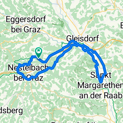
 Nestelbach - Raaba - Gössendorf -Schelchengraben - Prosdorf - Oberedelstauden - Krumegg - Nestelbach
- Distance
- 52.7 km
- Ascent
- 476 m
- Descent
- 424 m
- Location
- Nestelbach bei Graz, Styria, Austria
 schemerlhöhe-st. marein-petersdorf II-krumegg-schemerlhöhe
- Distance
- 25.4 km
- Ascent
- 325 m
- Descent
- 325 m
- Location
- Nestelbach bei Graz, Styria, Austria
 Apfelandtour
- Distance
- 60.2 km
- Ascent
- 529 m
- Descent
- 521 m
- Location
- Nestelbach bei Graz, Styria, Austria
 ¿èûÌ? nach ¿èûÌ?
- Distance
- 56.4 km
- Ascent
- 753 m
- Descent
- 706 m
- Location
- Nestelbach bei Graz, Styria, Austria
 Lanitzthal - St. Margarethen - Laßnitzhöhe
- Distance
- 40.4 km
- Ascent
- 256 m
- Descent
- 256 m
- Location
- Nestelbach bei Graz, Styria, Austria
 Kirchplatz 4, Nestelbach bei Graz to Kirchplatz 6, Nestelbach bei Graz
- Distance
- 38.3 km
- Ascent
- 335 m
- Descent
- 327 m
- Location
- Nestelbach bei Graz, Styria, Austria
 Hauptstraße 154, Laßnitzhöhe nach Moggau 4A, Laßnitzhöhe
- Distance
- 4.1 km
- Ascent
- 60 m
- Descent
- 60 m
- Location
- Nestelbach bei Graz, Styria, Austria