
Cycling in Untermaßfeld
Discover a map of 34 cycling routes and bike trails near Untermaßfeld, created by our community.
Region portrait
Get to know Untermaßfeld
Find the right bike route for you through Untermaßfeld, where we've got 34 cycle routes to explore.
1,469 km
Tracked distance
34
Cycle routes
1,316
Population
Community
Most active users in Untermaßfeld
From our community
The best bike routes in and around Untermaßfeld
kl.Runde
Cycling route in Untermaßfeld, Free State of Thuringia, Germany
- 28 km
- Distance
- 385 m
- Ascent
- 372 m
- Descent
ufeld-dillstädt-marisfeld-vachdorf-ufeld
Cycling route in Untermaßfeld, Free State of Thuringia, Germany
zwei kurze Anstiege nach Dillstädt und Marisfeld, ziemlich locker zu fahren
- 33.7 km
- Distance
- 272 m
- Ascent
- 241 m
- Descent
Teichstraße 9, Untermaßfeld nach Neumarktstraße 51, Metzels
Cycling route in Untermaßfeld, Free State of Thuringia, Germany
- 20.7 km
- Distance
- 226 m
- Ascent
- 50 m
- Descent
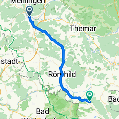
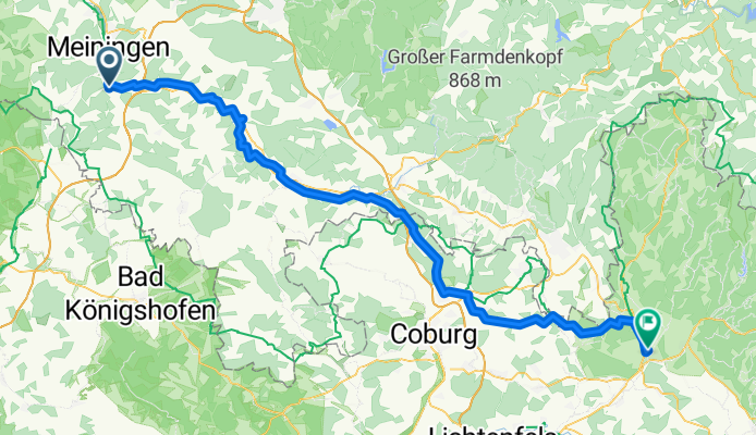
Walkmühlenweg, Meiningen nach Backhausgasse 7, Grabfeld
Cycling route in Untermaßfeld, Free State of Thuringia, Germany
- 6.7 km
- Distance
- 215 m
- Ascent
- 136 m
- Descent
Discover more routes
- transrennsteig
- Distance
- 101.4 km
- Ascent
- 1,398 m
- Descent
- 1,322 m
- Location
- Untermaßfeld, Free State of Thuringia, Germany
- Untermaßfeld-OberhofBhf-Untermaßfeld
- Distance
- 42.7 km
- Ascent
- 418 m
- Descent
- 128 m
- Location
- Untermaßfeld, Free State of Thuringia, Germany
- RUNDEDOLMAR060516
- Distance
- 39.1 km
- Ascent
- 555 m
- Descent
- 570 m
- Location
- Untermaßfeld, Free State of Thuringia, Germany
- untermaßfeld-hohe rhön-untermaßfeld
- Distance
- 83.7 km
- Ascent
- 1,174 m
- Descent
- 1,112 m
- Location
- Untermaßfeld, Free State of Thuringia, Germany
- ufeld-haubinda
- Distance
- 32.5 km
- Ascent
- 155 m
- Descent
- 116 m
- Location
- Untermaßfeld, Free State of Thuringia, Germany
- ufeld-schmalle
- Distance
- 34.3 km
- Ascent
- 233 m
- Descent
- 137 m
- Location
- Untermaßfeld, Free State of Thuringia, Germany
- gr. Gleichberg
- Distance
- 30.9 km
- Ascent
- 670 m
- Descent
- 307 m
- Location
- Untermaßfeld, Free State of Thuringia, Germany
- Römhild
- Distance
- 78.4 km
- Ascent
- 306 m
- Descent
- 307 m
- Location
- Untermaßfeld, Free State of Thuringia, Germany