
Cycling in Schlotheim
Discover a map of 33 cycling routes and bike trails near Schlotheim, created by our community.
Region portrait
Get to know Schlotheim
Find the right bike route for you through Schlotheim, where we've got 33 cycle routes to explore.
1,296 km
Tracked distance
33
Cycle routes
4,288
Population


From our community
The best bike routes in and around Schlotheim
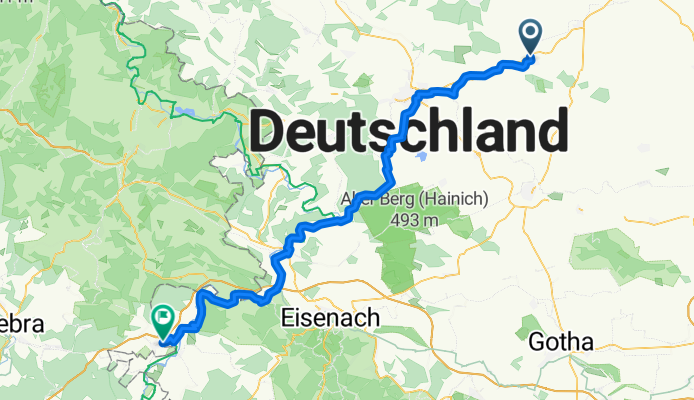
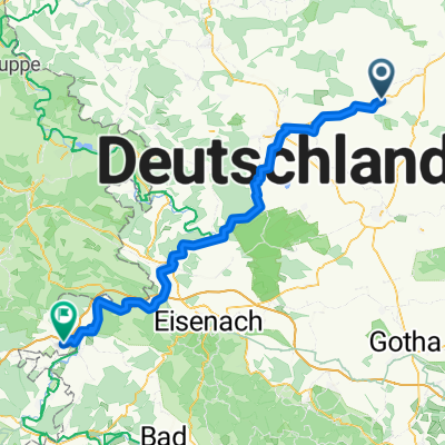
Körner - Dankmarshausen
Cycling route in Schlotheim, Thuringia, Germany
- 76.5 km
- Distance
- 578 m
- Ascent
- 593 m
- Descent
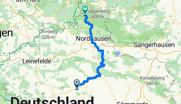


Steinweg 38, Nottertal-Heilinger Höhen nach Bergstraße 4, Nottertal-Heilinger Höhen
Cycling route in Schlotheim, Thuringia, Germany
- 38.5 km
- Distance
- 461 m
- Ascent
- 506 m
- Descent

Radrunde durch Schlotheim
Cycling route in Schlotheim, Thuringia, Germany
- 19.2 km
- Distance
- 225 m
- Ascent
- 226 m
- Descent
Discover more routes
 Sondershausen Bad Frankenhausen
- Distance
- 78.7 km
- Ascent
- 732 m
- Descent
- 707 m
- Location
- Schlotheim, Thuringia, Germany
 mittwoch
- Distance
- 21.6 km
- Ascent
- 146 m
- Descent
- 146 m
- Location
- Schlotheim, Thuringia, Germany
 schlotheim HIG SOODEN
- Distance
- 79.2 km
- Ascent
- 894 m
- Descent
- 915 m
- Location
- Schlotheim, Thuringia, Germany
 Erfurter Straße 5A, Schlotheim nach Bad Langensalza
- Distance
- 31.9 km
- Ascent
- 165 m
- Descent
- 215 m
- Location
- Schlotheim, Thuringia, Germany
 Weststraße 21, Nottertal-Heilinger Höhen nach Hauptstraße 26, Marolterode
- Distance
- 30.9 km
- Ascent
- 420 m
- Descent
- 380 m
- Location
- Schlotheim, Thuringia, Germany
 Weststraße 21, Nottertal-Heilinger Höhen nach Weststraße 23, Nottertal-Heilinger Höhen
- Distance
- 68.4 km
- Ascent
- 468 m
- Descent
- 466 m
- Location
- Schlotheim, Thuringia, Germany
 Schnelle Ausfahrt vom 8. August 17:33
- Distance
- 7.4 km
- Ascent
- 44 m
- Descent
- 43 m
- Location
- Schlotheim, Thuringia, Germany
 Ruhige Route
- Distance
- 78.9 km
- Ascent
- 427 m
- Descent
- 507 m
- Location
- Schlotheim, Thuringia, Germany