
Cycling in Haselbach
Discover a map of 67 cycling routes and bike trails near Haselbach, created by our community.
Region portrait
Get to know Haselbach
Find the right bike route for you through Haselbach, where we've got 67 cycle routes to explore. Most people get on their bikes to ride here in the month of July.
2,744 km
Tracked distance
67
Cycle routes
Community
Most active users in Haselbach


From our community
The best bike routes in and around Haselbach

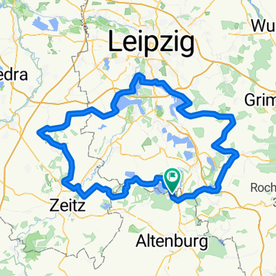
2-Länder CTF, Grenzerfahrung zwischen Thüringen und Sachsen
Cycling route in Haselbach, Thuringia, Germany
- 20.5 km
- Distance
- 108 m
- Ascent
- 107 m
- Descent

Rund um den Haselbacher See
Cycling route in Haselbach, Thuringia, Germany
- 43 km
- Distance
- 126 m
- Ascent
- 127 m
- Descent

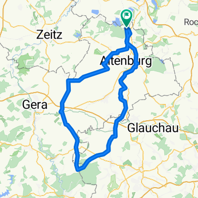
Frohburg-Waldenburg-Leinawald
Cycling route in Haselbach, Thuringia, Germany
- 101.9 km
- Distance
- 537 m
- Ascent
- 535 m
- Descent

Pleißental und Leinawald
Cycling route in Haselbach, Thuringia, Germany
- 44 km
- Distance
- 164 m
- Ascent
- 162 m
- Descent
Discover more routes
 Haselbacher See - Lucka - Großstolpen
- Distance
- 40.8 km
- Ascent
- 123 m
- Descent
- 123 m
- Location
- Haselbach, Thuringia, Germany
 Haselbacher See - Lucka
- Distance
- 19.4 km
- Ascent
- 84 m
- Descent
- 61 m
- Location
- Haselbach, Thuringia, Germany
 Altenburg-Am Stadtwald
- Distance
- 13 km
- Ascent
- 111 m
- Descent
- 48 m
- Location
- Haselbach, Thuringia, Germany
 Hohenmölsen - Markkleeberg - Bad Lausick
- Distance
- 139.7 km
- Ascent
- 241 m
- Descent
- 243 m
- Location
- Haselbach, Thuringia, Germany
 Haselb.-Wyhra-Eschefeld-Windischleuba
- Distance
- 25.7 km
- Ascent
- 110 m
- Descent
- 104 m
- Location
- Haselbach, Thuringia, Germany
 Frohburg-Prießnitz-Thräna
- Distance
- 45 km
- Ascent
- 176 m
- Descent
- 174 m
- Location
- Haselbach, Thuringia, Germany
 Teichwolframsdorf
- Distance
- 110.6 km
- Ascent
- 427 m
- Descent
- 427 m
- Location
- Haselbach, Thuringia, Germany
 Frohburg - Rochlitzer Berg - Bad Lausick
- Distance
- 95.1 km
- Ascent
- 404 m
- Descent
- 404 m
- Location
- Haselbach, Thuringia, Germany