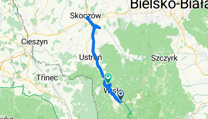
How cycling in Wis艂a could look like.

Cycling in Wis艂a

Discover a map of 1,107 cycling routes and bike trails near Wis艂a, created by our community.

Region portrait

Get to know Wis艂a

Find the right bike route for you through Wis艂a, where we've got 1,107 cycle routes to explore. Most people get on their bikes to ride here in the months of July and August.

69,269 km

Tracked distance

1,107

Cycle routes

11,379

Population

Community

Most active users in Wis艂a

Handpicked routes

Discover Wis艂a through these collections

From our community

The best bike routes in and around Wis艂a

Przez Barani膮 g贸r臋
MTBUnpaved
bikemindset
6

Przez Barani膮 g贸r臋

Cycling route in Wis艂a, Silesian Voivodeship, Poland

Start Wis艂a Czarne (obok ruiny Domu Turysty PTTK nad wodospadem). Dalej w dolin膮 Czarnej Wise艂ki, a偶 do idiotycznego znaku zakazu. Tam w prawo w g贸r臋 do Stec贸wki sk膮d czerwonym szlakiem przez Skrzy偶owanie do Buka (<span style="color: rgb(48, 48, 48); font-family: arial, sans-serif; font-size: 11px;">834 m n.p.m.), Karol贸wk臋 (</span><span style="color: rgb(48, 48, 48); font-family: arial, sans-serif; font-size: 11px;">931 m n.p.m.) do Schroniska pod Barani膮. St膮d (praktycznie na zakazie) kawa艂ek podjazdu ale dalej jakie艣100m noszenia bo kamienie sypkie, a korzenie g臋sto utkane. Ko艅c贸wka podjazdu to wielka przyjemno艣膰. Z Baraniej G贸ry (</span><span style="color: rgb(48, 48, 48); font-family: arial, sans-serif; font-size: 11px;">1205 m n.p.m.) w kierunku Magurki Wi艣la艅skiej (</span><span style="color: rgb(48, 48, 48); font-family: arial, sans-serif; font-size: 11px;">1127 m n.p.m.), Gawlasa (</span><span style="color: rgb(48, 48, 48); font-family: arial, sans-serif; font-size: 11px;">1073 m n.p.m.)</span><span style="color: rgb(48, 48, 48); font-family: arial, sans-serif; font-size: 11px;">i Malinowskiej Ska艂y, kt贸r膮 jednak mijam do艂em odbijaj膮c przecink膮 do szutrowej drogi, kt贸ra prowadzi na Prze艂臋cz Salmopolsk膮, sk膮d w d贸艂 w kierunku Wis艂y by po kilkuset metrach odbi膰 w prawo (uwaga, tylko przerwa w barierach) 偶贸艂tym szlakiem by interwa艂owo dotrze膰 do Smrekowca (</span><span style="color: rgb(48, 48, 48); font-family: arial, sans-serif; font-size: 11px;">817 m n.p.m.) sk膮d ju偶 dalej zielonym w kierunku 聽Czupla (</span><span style="color: rgb(48, 48, 48); font-family: arial, sans-serif; font-size: 11px;">882 m n.p.m.), jednak decyduj臋 si臋 nie omija膰 go tylko wdrapa艂em si臋 na wierzcho艂ek. Niestety zjazd do艣膰 zaro艣ni臋ty, poprzecinany powalonymi drzewami. Dalej ju偶 w kierunku Malinki (du偶e oznaczenia) i powr贸t do auta.</span>
35.9 km
Distance
1,113 m
Ascent
1,113 m
Descent
Sosz贸w-Sto偶ek-Kubalonka
MTBPavedUnpavedGravel
7

Sosz贸w-Sto偶ek-Kubalonka

Cycling route in Wis艂a, Silesian Voivodeship, Poland

Trasa Sosz贸w-Sto偶ek-Kubalonka-Wis艂a(asfaltem)
28.6 km
Distance
786 m
Ascent
786 m
Descent
2019.07.28 WKC G脫RAL (7) - Dooko艂a Pilska 1557 m npm
Road bikePavedUnpavedGravel
MARIO JONID艁O
5

2019.07.28 WKC G脫RAL (7) - Dooko艂a Pilska 1557 m npm

Cycling route in Wis艂a, Silesian Voivodeship, Poland

148.3 km
Distance
1,654 m
Ascent
1,654 m
Descent
2018.07.21 Wis艂a - O拧膷adnica - 膶adca - Skalite - Wis艂a
Road bikePaved
MARIO JONID艁O
4

2018.07.21 Wis艂a - O拧膷adnica - 膶adca - Skalite - Wis艂a

Cycling route in Wis艂a, Silesian Voivodeship, Poland

90 km
Distance
1,372 m
Ascent
1,370 m
Descent

Discover more routes