
Cycling in Oborniki Śląskie
Discover a map of 384 cycling routes and bike trails near Oborniki Śląskie, created by our community.
Region portrait
Get to know Oborniki Śląskie
Find the right bike route for you through Oborniki Śląskie, where we've got 384 cycle routes to explore. Most people get on their bikes to ride here in the months of June and July.
14,379 km
Tracked distance
384
Cycle routes
8,440
Population
Community
Most active users in Oborniki Śląskie


From our community
The best bike routes in and around Oborniki Śląskie
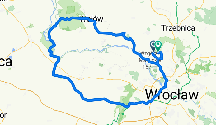
Pętla Wrocław - Lubiąż rowerem
Cycling route in Oborniki Śląskie, Lower Silesian Voivodeship, Poland
- 138.5 km
- Distance
- 418 m
- Ascent
- 416 m
- Descent


Wycieczka nr 2.
Cycling route in Oborniki Śląskie, Lower Silesian Voivodeship, Poland
- 10.3 km
- Distance
- 294 m
- Ascent
- 249 m
- Descent


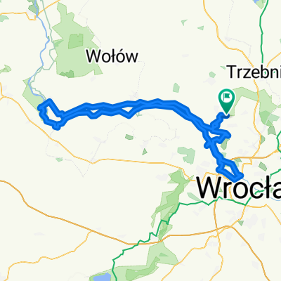
Wycieczka nr 8.
Cycling route in Oborniki Śląskie, Lower Silesian Voivodeship, Poland
- 18.4 km
- Distance
- 355 m
- Ascent
- 393 m
- Descent


Wycieczka nr 4.
Cycling route in Oborniki Śląskie, Lower Silesian Voivodeship, Poland
- 27 km
- Distance
- 471 m
- Ascent
- 508 m
- Descent
Discover more routes
 Wycieczka nr 6.
- Distance
- 9.4 km
- Ascent
- 303 m
- Descent
- 293 m
- Location
- Oborniki Śląskie, Lower Silesian Voivodeship, Poland
 Wieczka nr 3.
- Distance
- 7.5 km
- Ascent
- 194 m
- Descent
- 195 m
- Location
- Oborniki Śląskie, Lower Silesian Voivodeship, Poland
 Wycieczka nr 5.
- Distance
- 10.3 km
- Ascent
- 212 m
- Descent
- 185 m
- Location
- Oborniki Śląskie, Lower Silesian Voivodeship, Poland
 Wycieczka nr 1.
- Distance
- 11.3 km
- Ascent
- 288 m
- Descent
- 252 m
- Location
- Oborniki Śląskie, Lower Silesian Voivodeship, Poland
 Grębocice 2024 (9-10.03)
- Distance
- 162.2 km
- Ascent
- 654 m
- Descent
- 742 m
- Location
- Oborniki Śląskie, Lower Silesian Voivodeship, Poland
 drogą Stumilowego Lasu
- Distance
- 19.7 km
- Ascent
- 61 m
- Descent
- 60 m
- Location
- Oborniki Śląskie, Lower Silesian Voivodeship, Poland
 Route in Wisznia Mała
- Distance
- 123.3 km
- Ascent
- 318 m
- Descent
- 318 m
- Location
- Oborniki Śląskie, Lower Silesian Voivodeship, Poland
 Pętelka przez Wilczyn i Uraz
- Distance
- 23.3 km
- Ascent
- 62 m
- Descent
- 62 m
- Location
- Oborniki Śląskie, Lower Silesian Voivodeship, Poland