
Cycling in Gmina Łubniany
Discover a map of 100 cycling routes and bike trails near Gmina Łubniany, created by our community.
Region portrait
Get to know Gmina Łubniany
Find the right bike route for you through Gmina Łubniany, where we've got 100 cycle routes to explore. Most people get on their bikes to ride here in the months of June and July.
2,463 km
Tracked distance
100
Cycle routes
1,610
Population
Community
Most active users in Gmina Łubniany


From our community
The best bike routes in and around Gmina Łubniany

Opolska 110A, Łubniany do Księdza Augustyna Kordeckiego 2, Częstochowa
Cycling route in Gmina Łubniany, Opole Voivodeship, Poland
- 102.6 km
- Distance
- 599 m
- Ascent
- 479 m
- Descent

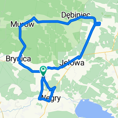
Rundr Turaw
Cycling route in Gmina Łubniany, Opole Voivodeship, Poland
- 63.8 km
- Distance
- 1,580 m
- Ascent
- 1,597 m
- Descent

Opolska 110A, Łubniany do Strażacka 6A, Mechnice
Cycling route in Gmina Łubniany, Opole Voivodeship, Poland
- 21.6 km
- Distance
- 36 m
- Ascent
- 96 m
- Descent

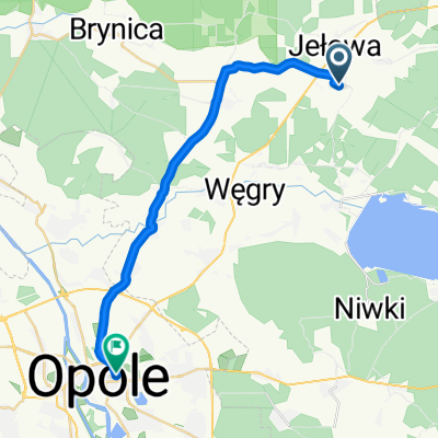
Opolska 110A, Łubniany do Opolska 110A, Łubniany
Cycling route in Gmina Łubniany, Opole Voivodeship, Poland
- 75.4 km
- Distance
- 219 m
- Ascent
- 219 m
- Descent
Discover more routes
 Opolska 110a, Łubniany do plac Myśliwca 1, Kamień Śląski
- Distance
- 37.4 km
- Ascent
- 176 m
- Descent
- 149 m
- Location
- Gmina Łubniany, Opole Voivodeship, Poland
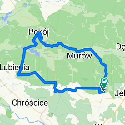
 Turawa Park
- Distance
- 20.3 km
- Ascent
- 36 m
- Descent
- 50 m
- Location
- Gmina Łubniany, Opole Voivodeship, Poland
 Trasa z Opolska 110A, Łubniany
- Distance
- 26.6 km
- Ascent
- 108 m
- Descent
- 102 m
- Location
- Gmina Łubniany, Opole Voivodeship, Poland
 Droga Wojewódzka 461 63, Dąbrówka Łubniańska do Oleska 63A, Dąbrówka Łubniańska
- Distance
- 0 km
- Ascent
- 0 m
- Descent
- 0 m
- Location
- Gmina Łubniany, Opole Voivodeship, Poland
 Droga Bez Nazwy do Droga Bez Nazwy
- Distance
- 56.3 km
- Ascent
- 269 m
- Descent
- 269 m
- Location
- Gmina Łubniany, Opole Voivodeship, Poland
 Opolska 99, Łubniany do Działkowa 2A, Krapkowice
- Distance
- 38.9 km
- Ascent
- 84 m
- Descent
- 79 m
- Location
- Gmina Łubniany, Opole Voivodeship, Poland
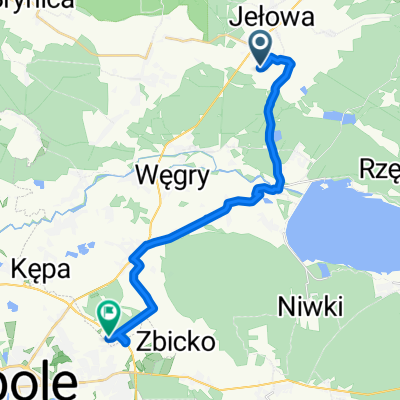
 Młyńska, Jełowa do A Kośnego, Opole
- Distance
- 22.1 km
- Ascent
- 64 m
- Descent
- 67 m
- Location
- Gmina Łubniany, Opole Voivodeship, Poland
 Kto relaks na rowerze lubi.
- Distance
- 59 km
- Ascent
- 165 m
- Descent
- 166 m
- Location
- Gmina Łubniany, Opole Voivodeship, Poland