
Cycling in Głuchołazy
Discover a map of 445 cycling routes and bike trails near Głuchołazy, created by our community.
Region portrait
Get to know Głuchołazy
Find the right bike route for you through Głuchołazy, where we've got 445 cycle routes to explore. Most people get on their bikes to ride here in the months of May and August.
46,931 km
Tracked distance
445
Cycle routes
15,120
Population
Community
Most active users in Głuchołazy


Handpicked routes
Discover Głuchołazy through these collections
Tour
From our community
The best bike routes in and around Głuchołazy
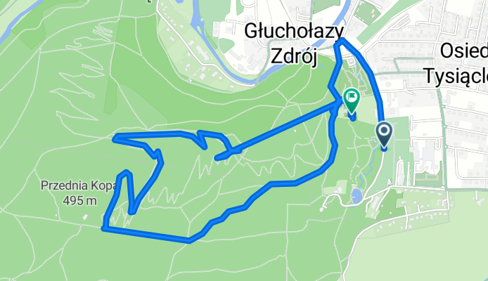
Parkowa, Głuchołazy do Kamieniec, Głuchołazy
Cycling route in Głuchołazy, Opole Voivodeship, Poland
- 5.4 km
- Distance
- 241 m
- Ascent
- 261 m
- Descent
Wieniawskiego 2A do Wieniawskiego 2A
Cycling route in Głuchołazy, Opole Voivodeship, Poland
- 57.9 km
- Distance
- 782 m
- Ascent
- 788 m
- Descent

Kamieniec, Głuchołazy do Kamieniec, Głuchołazy
Cycling route in Głuchołazy, Opole Voivodeship, Poland
- 7.4 km
- Distance
- 234 m
- Ascent
- 233 m
- Descent

Sławniowice - Wrocław (Grodków, Oława)
Cycling route in Głuchołazy, Opole Voivodeship, Poland
- 100.1 km
- Distance
- 65 m
- Ascent
- 261 m
- Descent
Discover more routes
 MTB Gold Hill Glucholazy
- Distance
- 29.2 km
- Ascent
- 876 m
- Descent
- 881 m
- Location
- Głuchołazy, Opole Voivodeship, Poland
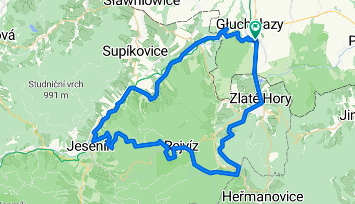
 Głuchołazy - Jesenik - Głuchołazy 12_11_11
- Distance
- 56.3 km
- Ascent
- 1,149 m
- Descent
- 1,149 m
- Location
- Głuchołazy, Opole Voivodeship, Poland
 chorwacja wegry off
- Distance
- 1,154.1 km
- Ascent
- 1,999 m
- Descent
- 2,278 m
- Location
- Głuchołazy, Opole Voivodeship, Poland
 2007-05-26 Glucholazy Kopa Biskupia Głuchołazy
- Distance
- 36.2 km
- Ascent
- 784 m
- Descent
- 786 m
- Location
- Głuchołazy, Opole Voivodeship, Poland
 Rozprostować skrzydła
- Distance
- 26.3 km
- Ascent
- 117 m
- Descent
- 116 m
- Location
- Głuchołazy, Opole Voivodeship, Poland
 Okrążenie Kotliny Kłodzkiej
- Distance
- 311.1 km
- Ascent
- 2,720 m
- Descent
- 2,718 m
- Location
- Głuchołazy, Opole Voivodeship, Poland
 Sławniowice - Sławniowice (przez Jesenik, Czervenohorske Sedlo, Louczną nad Desną, Dlouhe Stranie, Kouty nad Desnou, Czervenohorske Sedlo, Jesenik)
- Distance
- 112.4 km
- Ascent
- 1,990 m
- Descent
- 1,990 m
- Location
- Głuchołazy, Opole Voivodeship, Poland
 Dlouhe strane (via Rejviz)
- Distance
- 122.4 km
- Ascent
- 2,453 m
- Descent
- 2,453 m
- Location
- Głuchołazy, Opole Voivodeship, Poland