
Cycling in Tiers
Discover a map of 66 cycling routes and bike trails near Tiers, created by our community.
Region portrait
Get to know Tiers
Find the right bike route for you through Tiers, where we've got 66 cycle routes to explore. Most people get on their bikes to ride here in the months of July and August.
2,863 km
Tracked distance
66
Cycle routes
406
Population
Community
Most active users in Tiers


From our community
The best bike routes in and around Tiers

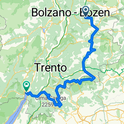
Nigerpass / Rosengarten-Latemar
Cycling route in Tiers, Trentino-Alto Adige, Italy
- 32.7 km
- Distance
- 1,110 m
- Ascent
- 1,110 m
- Descent

St. Zyprian Moena
Cycling route in Tiers, Trentino-Alto Adige, Italy
- 22.4 km
- Distance
- 740 m
- Ascent
- 648 m
- Descent

StZyprian-Moena
Cycling route in Tiers, Trentino-Alto Adige, Italy
- 22.5 km
- Distance
- 721 m
- Ascent
- 615 m
- Descent

07 - Nova Levante_Welschnofen-Obergummer_Gummer(San Valentino) - Nova Levante/Welschnofen-Obergummer/Gummer(San Valentino)
Cycling route in Tiers, Trentino-Alto Adige, Italy
- 49.6 km
- Distance
- 2,049 m
- Ascent
- 2,046 m
- Descent
Discover more routes
 Santa Kathrein 28, Völs am Schlern nach Weingartnerweg, Völs am Schlern
- Distance
- 7.3 km
- Ascent
- 180 m
- Descent
- 495 m
- Location
- Tiers, Trentino-Alto Adige, Italy
 bergamo
- Distance
- 15.1 km
- Ascent
- 1,628 m
- Descent
- 836 m
- Location
- Tiers, Trentino-Alto Adige, Italy
 Nova Levante_Welschnofen-Obergummer_Gummer (San Valentino)
- Distance
- 42 km
- Ascent
- 1,674 m
- Descent
- 1,674 m
- Location
- Tiers, Trentino-Alto Adige, Italy
 AlpenX 2020 Teil2
- Distance
- 255 km
- Ascent
- 6,297 m
- Descent
- 7,248 m
- Location
- Tiers, Trentino-Alto Adige, Italy
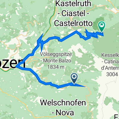
 Schillertour / Rosengarten-Latemar
- Distance
- 10.7 km
- Ascent
- 542 m
- Descent
- 480 m
- Location
- Tiers, Trentino-Alto Adige, Italy
 St-Zyprian-Straße 69, Tiers nach Via Compatsch 62, Kastelruth
- Distance
- 36.9 km
- Ascent
- 2,198 m
- Descent
- 1,480 m
- Location
- Tiers, Trentino-Alto Adige, Italy
 Tierser Runde
- Distance
- 11.4 km
- Ascent
- 738 m
- Descent
- 123 m
- Location
- Tiers, Trentino-Alto Adige, Italy
 Dynamite Trail - Tag 6 (Tiers - Refugio Refavaie)
- Distance
- 57.7 km
- Ascent
- 1,897 m
- Descent
- 1,791 m
- Location
- Tiers, Trentino-Alto Adige, Italy