
Cycling in Prettau
Discover a map of 51 cycling routes and bike trails near Prettau, created by our community.
Region portrait
Get to know Prettau
Find the right bike route for you through Prettau, where we've got 51 cycle routes to explore. Most people get on their bikes to ride here in the month of August.
2,332 km
Tracked distance
51
Cycle routes
337
Population
Community
Most active users in Prettau


From our community
The best bike routes in and around Prettau
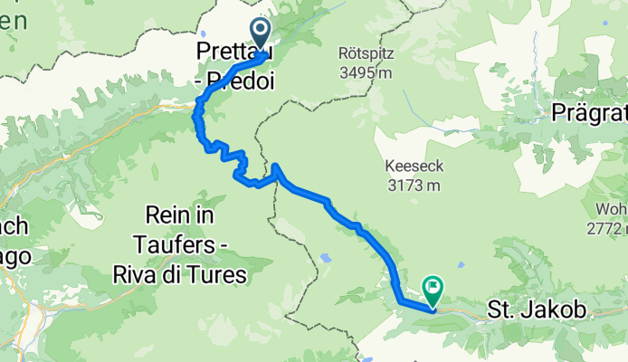
Von Prettau bis Sankt Jakob in Defereggen
Cycling route in Prettau, Trentino-Alto Adige, Italy
- 37 km
- Distance
- 1,995 m
- Ascent
- 2,042 m
- Descent
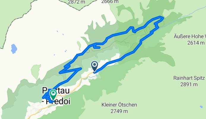
Anello: Predoi - FuchsAlm - TauernAlm - Casere
Cycling route in Prettau, Trentino-Alto Adige, Italy
- 15.2 km
- Distance
- 749 m
- Ascent
- 880 m
- Descent

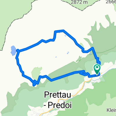
Casere - Rif.Tridentina - Rif.Vetta d'Italia
Cycling route in Prettau, Trentino-Alto Adige, Italy
- 19.9 km
- Distance
- 1,123 m
- Ascent
- 1,124 m
- Descent

Casere - TauernAlm - Rif.Vetta d'Italia
Cycling route in Prettau, Trentino-Alto Adige, Italy
- 15.3 km
- Distance
- 968 m
- Ascent
- 966 m
- Descent
Discover more routes
 Anello: Casere - Waldnersee
- Distance
- 11.6 km
- Ascent
- 909 m
- Descent
- 906 m
- Location
- Prettau, Trentino-Alto Adige, Italy
 Prettau -Plätzwiese
- Distance
- 86.5 km
- Ascent
- 2,397 m
- Descent
- 1,862 m
- Location
- Prettau, Trentino-Alto Adige, Italy
 S. Pietro - Molini di Tures
- Distance
- 23.3 km
- Ascent
- 292 m
- Descent
- 683 m
- Location
- Prettau, Trentino-Alto Adige, Italy
 Casere - Rifugio Tridentina - Vetta D'Italia
- Distance
- 20 km
- Ascent
- 1,112 m
- Descent
- 1,107 m
- Location
- Prettau, Trentino-Alto Adige, Italy
 Malga Alprechalm
- Distance
- 5.2 km
- Ascent
- 569 m
- Descent
- 20 m
- Location
- Prettau, Trentino-Alto Adige, Italy
 Escursione invernale a Steger Alm
- Distance
- 4.2 km
- Ascent
- 507 m
- Descent
- 0 m
- Location
- Prettau, Trentino-Alto Adige, Italy
 2015 Prettau-Waldner-Tauernalm (13.08.2015)
- Distance
- 22 km
- Ascent
- 807 m
- Descent
- 810 m
- Location
- Prettau, Trentino-Alto Adige, Italy
 Chata Rifugio
- Distance
- 14.9 km
- Ascent
- 1,070 m
- Descent
- 1,070 m
- Location
- Prettau, Trentino-Alto Adige, Italy