
Cycling in Azuay
Discover a map of 693 cycling routes and bike trails in Azuay, created by our community.
Region portrait
Get to know Azuay
Find the right bike route for you through Azuay, where we've got 693 cycle routes to explore. Most people get on their bikes to ride here in the months of June and July.
19,872 km
Tracked distance
693
Cycle routes
Community
Most active users in Azuay


Handpicked routes
Discover Azuay through these collections
From our community
The best bike routes in Azuay


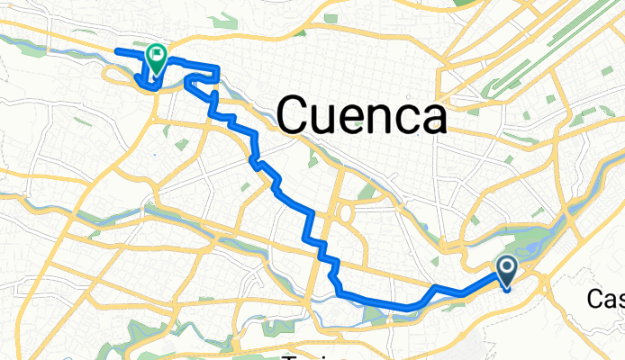
Turubamba, Cuenca to Victor Manuel Albornoz, Cuenca
Cycling route in Cuenca, Azuay, Ecuador
- 9.8 km
- Distance
- 127 m
- Ascent
- 65 m
- Descent


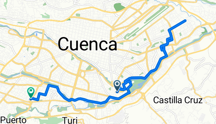


De Saraurco 106, Cuenca a Saraurco 106, Cuenca
Cycling route in Cuenca, Azuay, Ecuador
- 29 km
- Distance
- 1,214 m
- Ascent
- 1,214 m
- Descent


De 5XPX+J4C, Chiquintad a Parque Central de Chiquintad
Cycling route in Cuenca, Azuay, Ecuador
- 52.8 km
- Distance
- 5,997 m
- Ascent
- 5,993 m
- Descent
Discover more routes
 De Hugo Vivar Flores 5-62, Cuenca a 3XF6+RH5, Cuenca
- Distance
- 18.4 km
- Ascent
- 871 m
- Descent
- 911 m
- Location
- Cuenca, Azuay, Ecuador
 De Unnamed Road a Via Cuenca - Macas
- Distance
- 20 km
- Ascent
- 538 m
- Descent
- 196 m
- Location
- Gualaceo, Azuay, Ecuador
 De De La Passiflora, Cuenca a Cruces de Barabón, Cuenca
- Distance
- 17.5 km
- Ascent
- 719 m
- Descent
- 712 m
- Location
- Cuenca, Azuay, Ecuador
 De Medardo A. Silva 27, Cuenca a Medardo A. Silva 1-17, Cuenca
- Distance
- 9.8 km
- Ascent
- 22 m
- Descent
- 28 m
- Location
- Cuenca, Azuay, Ecuador
 Ruta a Del Bandoneón 59, Cuenca
- Distance
- 21.2 km
- Ascent
- 257 m
- Descent
- 134 m
- Location
- Cuenca, Azuay, Ecuador
 paute y guala
- Distance
- 57.1 km
- Ascent
- 1,524 m
- Descent
- 1,538 m
- Location
- Llacao, Azuay, Ecuador
 De Avenida González Suárez 543, Cuenca a La República 472, Cuenca
- Distance
- 23.7 km
- Ascent
- 294 m
- Descent
- 284 m
- Location
- Cuenca, Azuay, Ecuador
 De Diego de Almagro, Cuenca a Avenida Mirador de Turi, Cuenca
- Distance
- 6 km
- Ascent
- 193 m
- Descent
- 89 m
- Location
- Cuenca, Azuay, Ecuador
Cycling regions in Azuay
See where people are biking in Ecuador
Popular cycling regions in Ecuador

