
Cycling in Hagerstown
Discover a map of 9 cycling routes and bike trails near Hagerstown, created by our community.
Region portrait
Get to know Hagerstown
Find the right bike route for you through Hagerstown, where we've got 9 cycle routes to explore.
184 km
Tracked distance
9
Cycle routes
1,787
Population
Community
Most active users in Hagerstown


From our community
The best bike routes in and around Hagerstown


Recovered Route
Cycling route in Hagerstown, Indiana, United States
- 39.2 km
- Distance
- 133 m
- Ascent
- 175 m
- Descent
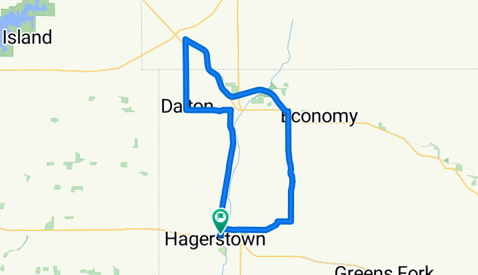
Hagerstown-Dalton-Losantville-Economy-Hagerstown
Cycling route in Hagerstown, Indiana, United States
- 35.2 km
- Distance
- 143 m
- Ascent
- 146 m
- Descent

Route to 730–782 Industries Rd, Richmond
Cycling route in Hagerstown, Indiana, United States
- 23.9 km
- Distance
- 193 m
- Ascent
- 214 m
- Descent
Discover more routes
 Newman Road 9305, Williamsburg to Newman Road 9305, Williamsburg
- Distance
- 11.4 km
- Ascent
- 60 m
- Descent
- 33 m
- Location
- Hagerstown, Indiana, United States
 Smoky Row Road 8871, Greens Fork to Smoky Row Road 8871, Greens Fork
- Distance
- 9.8 km
- Ascent
- 13 m
- Descent
- 15 m
- Location
- Hagerstown, Indiana, United States
 8512–8990 S County Road 1200 W, Losantville to S 534 E, Selma
- Distance
- 9.9 km
- Ascent
- 52 m
- Descent
- 78 m
- Location
- Hagerstown, Indiana, United States
 Poplar Street 400 N, Economy to Poplar Street 400 N, Economy
- Distance
- 13 km
- Ascent
- 78 m
- Descent
- 59 m
- Location
- Hagerstown, Indiana, United States
 10070–10198 US-35, Losantville to 5837–5935 US-35, Williamsburg
- Distance
- 25.8 km
- Ascent
- 122 m
- Descent
- 142 m
- Location
- Hagerstown, Indiana, United States