
Cycling in Owensboro
Discover a map of 23 cycling routes and bike trails near Owensboro, created by our community.
Region portrait
Get to know Owensboro
Find the right bike route for you through Owensboro, where we've got 23 cycle routes to explore.
449 km
Tracked distance
23
Cycle routes
57,265
Population
Community
Most active users in Owensboro


From our community
The best bike routes in and around Owensboro


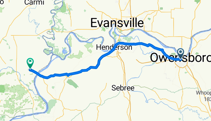
US-231 S, Owensboro to E Byers Ave, Owensboro
Cycling route in Owensboro, Kentucky, United States
- 16.1 km
- Distance
- 22 m
- Ascent
- 25 m
- Descent

8 mile Underground and Ramblin River
Cycling route in Owensboro, Kentucky, United States
- 13.2 km
- Distance
- 30 m
- Ascent
- 28 m
- Descent
040.Owensboro-Shawneetown_118
Cycling route in Owensboro, Kentucky, United States
- 111.7 km
- Distance
- 224 m
- Ascent
- 218 m
- Descent
Discover more routes
 Overstreet Road 166, Owensboro to Overstreet Road 166, Owensboro
- Distance
- 4.5 km
- Ascent
- 78 m
- Descent
- 77 m
- Location
- Owensboro, Kentucky, United States
 Jack C. Fisher Walking Trail, Owensboro to South Chestnut Grove Road 1370, Lewisport
- Distance
- 25.6 km
- Ascent
- 265 m
- Descent
- 247 m
- Location
- Owensboro, Kentucky, United States
 Bon Ton prep route 75 mi
- Distance
- 118.9 km
- Ascent
- 892 m
- Descent
- 893 m
- Location
- Owensboro, Kentucky, United States
 West 5th Street 1801, Owensboro to East 4th Street 3012, Owensboro
- Distance
- 6.5 km
- Ascent
- 6 m
- Descent
- 3 m
- Location
- Owensboro, Kentucky, United States
 going
going- Distance
- 3.9 km
- Ascent
- 16 m
- Descent
- 18 m
- Location
- Owensboro, Kentucky, United States
 Greenbelt
- Distance
- 10.6 km
- Ascent
- 42 m
- Descent
- 38 m
- Location
- Owensboro, Kentucky, United States
 118 W Veterans Blvd, Owensboro to 10805 Red Hill Maxwell Rd, Utica
- Distance
- 34.2 km
- Ascent
- 158 m
- Descent
- 137 m
- Location
- Owensboro, Kentucky, United States
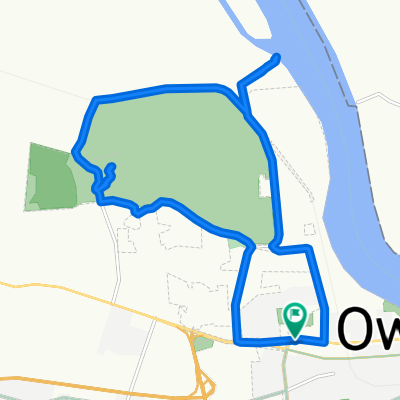 around Ben Hall State Park
- Distance
- 18 km
- Ascent
- 58 m
- Descent
- 57 m
- Location
- Owensboro, Kentucky, United States