
Cycling in Morrow
Discover a map of 13 cycling routes and bike trails near Morrow, created by our community.
Region portrait
Get to know Morrow
Find the right bike route for you through Morrow, where we've got 13 cycle routes to explore.
1,378 km
Tracked distance
13
Cycle routes
1,188
Population
Community
Most active users in Morrow

From our community
The best bike routes in and around Morrow

Morrow, OH to Augusta, KY
Cycling route in Morrow, Ohio, United States
This route connects my Lafayette - Cincinnati route and the Little Miami Trail to Augusta Kentucky via a car ferry. From Augusta my Crittenden to Maysville can be used to travel on in Kentucky.
- 85.7 km
- Distance
- 162 m
- Ascent
- 208 m
- Descent


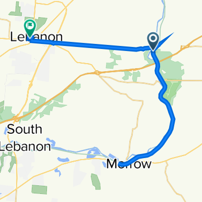
little Miami Morrow to Oregonia
Cycling route in Morrow, Ohio, United States
- 14 km
- Distance
- 114 m
- Ascent
- 97 m
- Descent

5776 Montrose Ct, Morrow to 5776 Montrose Ct, Morrow
Cycling route in Morrow, Ohio, United States
- 32.9 km
- Distance
- 125 m
- Ascent
- 134 m
- Descent
Discover more routes
 Center St, Morrow to Center St, Morrow
- Distance
- 21.6 km
- Ascent
- 81 m
- Descent
- 81 m
- Location
- Morrow, Ohio, United States
 21: Morrow to South Lebanon
- Distance
- 12.5 km
- Ascent
- 121 m
- Descent
- 132 m
- Location
- Morrow, Ohio, United States
 Caesar Creek
- Distance
- 38.3 km
- Ascent
- 220 m
- Descent
- 215 m
- Location
- Morrow, Ohio, United States
 Recovered Route
- Distance
- 13.7 km
- Ascent
- 31 m
- Descent
- 44 m
- Location
- Morrow, Ohio, United States
 5720–5736 SR-350, Oregonia to 200–250 Miranda St, Morrow
- Distance
- 8.4 km
- Ascent
- 0 m
- Descent
- 10 m
- Location
- Morrow, Ohio, United States
 150 E Pike St, Morrow to 148 Little Deer Path Ln, La Follette
- Distance
- 518.6 km
- Ascent
- 4,218 m
- Descent
- 4,036 m
- Location
- Morrow, Ohio, United States
 Steady ride in Springfield
- Distance
- 554.2 km
- Ascent
- 1,685 m
- Descent
- 1,953 m
- Location
- Morrow, Ohio, United States
 39.427° N -84.107° W to 39.435° N -84.208° W
- Distance
- 32.9 km
- Ascent
- 175 m
- Descent
- 168 m
- Location
- Morrow, Ohio, United States