
Cycling in Shell Point
Discover a map of 57 cycling routes and bike trails near Shell Point, created by our community.
Region portrait
Get to know Shell Point
Find the right bike route for you through Shell Point, where we've got 57 cycle routes to explore. Most people get on their bikes to ride here in the months of August and September.
1,151 km
Tracked distance
57
Cycle routes
2,817
Population
Community
Most active users in Shell Point


From our community
The best bike routes in and around Shell Point


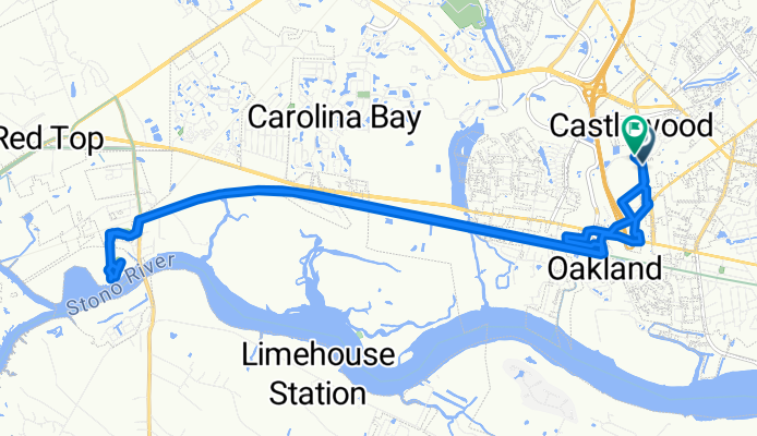
Sam Rittenberg Boulevard to Sam Rittenberg Boulevard
Cycling route in Shell Point, South Carolina, United States
- 23.6 km
- Distance
- 554 m
- Ascent
- 499 m
- Descent

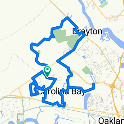
Get Over It - Extended Route
Cycling route in Shell Point, South Carolina, United States
- 50.2 km
- Distance
- 73 m
- Ascent
- 73 m
- Descent

Greenway Ride
Cycling route in Shell Point, South Carolina, United States
- 27.2 km
- Distance
- 46 m
- Ascent
- 45 m
- Descent

XStay-Sanders-BF-HuntClub-BSwamp
Cycling route in Shell Point, South Carolina, United States
- 11.8 km
- Distance
- 40 m
- Ascent
- 45 m
- Descent
Discover more routes
 Stono River - Ripley Point
- Distance
- 13.8 km
- Ascent
- 49 m
- Descent
- 53 m
- Location
- Shell Point, South Carolina, United States
 Taking the Greenway Home
- Distance
- 40.3 km
- Ascent
- 62 m
- Descent
- 64 m
- Location
- Shell Point, South Carolina, United States
 14 Beaufort - Charleston
- Distance
- 93.9 km
- Ascent
- 128 m
- Descent
- 131 m
- Location
- Shell Point, South Carolina, United States
 Recovered Route
- Distance
- 12.6 km
- Ascent
- 328 m
- Descent
- 323 m
- Location
- Shell Point, South Carolina, United States
 ECG 14
- Distance
- 149.4 km
- Ascent
- 103 m
- Descent
- 100 m
- Location
- Shell Point, South Carolina, United States
 Jaunt around the neighborhood
- Distance
- 36.6 km
- Ascent
- 62 m
- Descent
- 62 m
- Location
- Shell Point, South Carolina, United States
 Restful route in Charleston
- Distance
- 9.9 km
- Ascent
- 7 m
- Descent
- 10 m
- Location
- Shell Point, South Carolina, United States
 West Ashley Greenway
- Distance
- 13.8 km
- Ascent
- 56 m
- Descent
- 63 m
- Location
- Shell Point, South Carolina, United States