
Cycling in Litchfield
Discover a map of 14 cycling routes and bike trails near Litchfield, created by our community.
Region portrait
Get to know Litchfield
Find the right bike route for you through Litchfield, where we've got 14 cycle routes to explore.
555 km
Tracked distance
14
Cycle routes
1,258
Population
Community
Most active users in Litchfield


From our community
The best bike routes in and around Litchfield

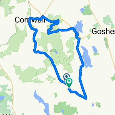
The Goshen loop
Cycling route in Litchfield, Connecticut, United States
- 16.4 km
- Distance
- 198 m
- Ascent
- 193 m
- Descent

Lake Woodridge
Cycling route in Litchfield, Connecticut, United States
- 12.7 km
- Distance
- 170 m
- Ascent
- 171 m
- Descent

Flat Rocks to Lime Rock via West Cornwall
Cycling route in Litchfield, Connecticut, United States
- 51.9 km
- Distance
- 742 m
- Ascent
- 743 m
- Descent

East Cornwall to Lime Rock and back to West Cornwall
Cycling route in Litchfield, Connecticut, United States
- 44.9 km
- Distance
- 389 m
- Ascent
- 580 m
- Descent
Discover more routes
 Ives Road 45, Goshen to West Street 46, Litchfield
- Distance
- 19.7 km
- Ascent
- 73 m
- Descent
- 128 m
- Location
- Litchfield, Connecticut, United States
 Litchfield ride
- Distance
- 33.5 km
- Ascent
- 322 m
- Descent
- 322 m
- Location
- Litchfield, Connecticut, United States
 Route to 342 Main St, Great Barrington
- Distance
- 65.4 km
- Ascent
- 915 m
- Descent
- 1,019 m
- Location
- Litchfield, Connecticut, United States
 Route to 127–199 Webster Rd, Morris
- Distance
- 4.8 km
- Ascent
- 80 m
- Descent
- 76 m
- Location
- Litchfield, Connecticut, United States
 test
test- Distance
- 77 km
- Ascent
- 717 m
- Descent
- 834 m
- Location
- Litchfield, Connecticut, United States
 443 Torrington Rd, Litchfield to 443 Torrington Rd, Litchfield
- Distance
- 10 km
- Ascent
- 147 m
- Descent
- 146 m
- Location
- Litchfield, Connecticut, United States
 litchfield 75
- Distance
- 118.9 km
- Ascent
- 940 m
- Descent
- 940 m
- Location
- Litchfield, Connecticut, United States
 Route in Litchfield
- Distance
- 31.7 km
- Ascent
- 646 m
- Descent
- 639 m
- Location
- Litchfield, Connecticut, United States