
Cycling in Shelburne Falls
Discover a map of 8 cycling routes and bike trails near Shelburne Falls, created by our community.
Region portrait
Get to know Shelburne Falls
Find the right bike route for you through Shelburne Falls, where we've got 8 cycle routes to explore.
574 km
Tracked distance
8
Cycle routes
1,731
Population


From our community
The best bike routes in and around Shelburne Falls
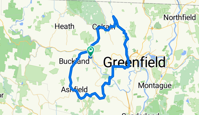
Covered Bridges of Franklin Cty MAss - 4
Cycling route in Shelburne Falls, Massachusetts, United States
- 78.1 km
- Distance
- 777 m
- Ascent
- 776 m
- Descent

Mohawk Tail from Shelburne Falls to North Adams, MA
Cycling route in Shelburne Falls, Massachusetts, United States
Gorgeous climb
View points over North Adams
Rapid descend into North Adams
- 44.4 km
- Distance
- 569 m
- Ascent
- 507 m
- Descent

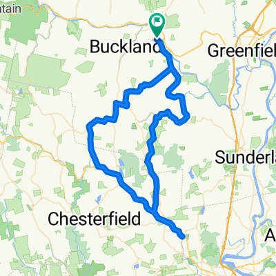
Shelburne Falls Figure Eight loop: serious hills
Cycling route in Shelburne Falls, Massachusetts, United States
I rode this last night(7/20/2010), with the Bicycle World Tuesday night ride group. We rode it pretty fast. There are basically only two hills, Clesson Brook Road, and Whitcomb Hill Road. There are other hills in between, but mostly inconsequential. Whitcomb is an average of 9% for two miles. The ride back from Whitcomb is a fast ride, averaging 25mph or so on the flats, and up to 29 or 30 on the downhills with a paceline. Of course, the descent into Monroe is much faster, averaging more like 45-50mph. The Buckland town line is a tough sprint, after all those hills, and fast paceline for the previous 15 miles or so. Great ride, and great training ride!
- 76.3 km
- Distance
- 952 m
- Ascent
- 952 m
- Descent

Shelburne Falls Figure Eight
Cycling route in Shelburne Falls, Massachusetts, United States
- 76.3 km
- Distance
- 1,015 m
- Ascent
- 1,015 m
- Descent
Discover more routes
 Deerfield River Tour
- Distance
- 92.1 km
- Ascent
- 1,028 m
- Descent
- 1,026 m
- Location
- Shelburne Falls, Massachusetts, United States
 hymff
hymff- Distance
- 46.6 km
- Ascent
- 586 m
- Descent
- 563 m
- Location
- Shelburne Falls, Massachusetts, United States
 Sunday Morning Ride 7-6-2008
- Distance
- 80 km
- Ascent
- 1,193 m
- Descent
- 1,180 m
- Location
- Shelburne Falls, Massachusetts, United States
 July 1 2008
- Distance
- 80 km
- Ascent
- 1,592 m
- Descent
- 1,574 m
- Location
- Shelburne Falls, Massachusetts, United States