
Cycling in West Wareham
Discover a map of 9 cycling routes and bike trails near West Wareham, created by our community.
Region portrait
Get to know West Wareham
Find the right bike route for you through West Wareham, where we've got 9 cycle routes to explore.
1,106 km
Tracked distance
9
Cycle routes
2,064
Population
Community
Most active users in West Wareham


From our community
The best bike routes in and around West Wareham

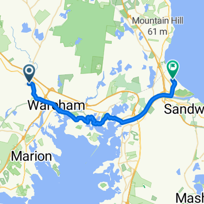
60 Bryant Ln, Rochester to 60 Bryant Ln, Rochester
Cycling route in West Wareham, Massachusetts, United States
- 17.3 km
- Distance
- 103 m
- Ascent
- 100 m
- Descent

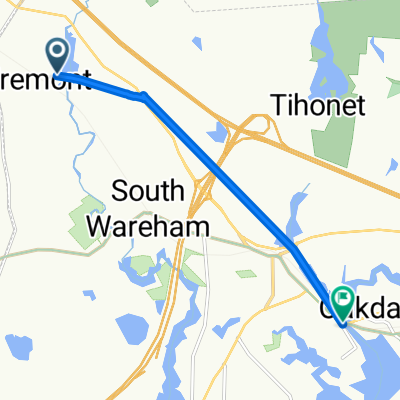
19 Tobey Rd, Wareham to Bourne Bridge, Buzzards Bay
Cycling route in West Wareham, Massachusetts, United States
- 17.6 km
- Distance
- 123 m
- Ascent
- 146 m
- Descent

85 Fearing Hill Rd, West Wareham to 9 S Main St, Assonet
Cycling route in West Wareham, Massachusetts, United States
- 32.9 km
- Distance
- 186 m
- Ascent
- 203 m
- Descent

578 Wareham St, Middleboro to 208 Main St, Wareham
Cycling route in West Wareham, Massachusetts, United States
- 13.2 km
- Distance
- 70 m
- Ascent
- 100 m
- Descent
Discover more routes
 Main Street to Main Street
- Distance
- 6.7 km
- Ascent
- 36 m
- Descent
- 27 m
- Location
- West Wareham, Massachusetts, United States
 Pine View Terrace 193, Wareham to Cranberry Road 3R, Plymouth
- Distance
- 19 km
- Ascent
- 125 m
- Descent
- 125 m
- Location
- West Wareham, Massachusetts, United States
 60 Bryant Ln, Rochester to 60 Bryant Ln, Rochester
- Distance
- 9.4 km
- Ascent
- 74 m
- Descent
- 80 m
- Location
- West Wareham, Massachusetts, United States
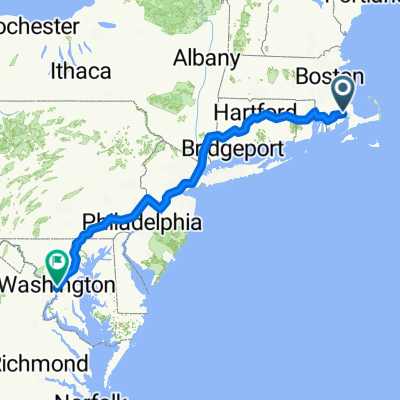 Main Street to Constitution Avenue Northwest
- Distance
- 959.4 km
- Ascent
- 9,116 m
- Descent
- 9,123 m
- Location
- West Wareham, Massachusetts, United States
 Main Street to Clark Road
- Distance
- 30.5 km
- Ascent
- 244 m
- Descent
- 245 m
- Location
- West Wareham, Massachusetts, United States