
Cycling in Circle Pines
Discover a map of 42 cycling routes and bike trails near Circle Pines, created by our community.
Region portrait
Get to know Circle Pines
Find the right bike route for you through Circle Pines, where we've got 42 cycle routes to explore. Most people get on their bikes to ride here in the month of June.
597 km
Tracked distance
42
Cycle routes
4,918
Population
Community
Most active users in Circle Pines


From our community
The best bike routes in and around Circle Pines

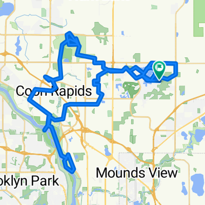
Rice Creek Chain all paved trails & 2 off trails
Cycling route in Circle Pines, Minnesota, United States
- 10.4 km
- Distance
- 42 m
- Ascent
- 43 m
- Descent

Steady ride in Lino Lakes
Cycling route in Circle Pines, Minnesota, United States
- 26.4 km
- Distance
- 60 m
- Ascent
- 59 m
- Descent

B2B00324 55014>55413 via Lexington, Co Rd C, Minneapolis Diagonal Trail
Cycling route in Circle Pines, Minnesota, United States
- 25.2 km
- Distance
- 66 m
- Ascent
- 60 m
- Descent

B2B00390 55126>55344 viaHodgson/Victoria/Como/Intercampus/4thSE/StoneArch/CedarTrail/Hopkins/ShadyOak
Cycling route in Circle Pines, Minnesota, United States
- 51.7 km
- Distance
- 154 m
- Ascent
- 160 m
- Descent
Discover more routes
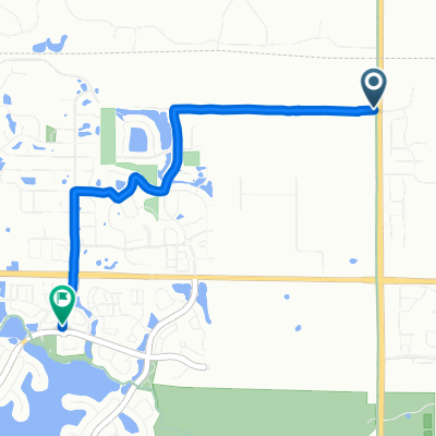
 202 Elm St, Lino Lakes to 628–630 Town Center Pkwy, Lino Lakes
- Distance
- 5 km
- Ascent
- 30 m
- Descent
- 35 m
- Location
- Circle Pines, Minnesota, United States
 Gravel
- Distance
- 73.2 km
- Ascent
- 103 m
- Descent
- 100 m
- Location
- Circle Pines, Minnesota, United States
 117th Ln NE, Blaine to 117th Ln NE, Blaine
- Distance
- 76.5 km
- Ascent
- 221 m
- Descent
- 221 m
- Location
- Circle Pines, Minnesota, United States
 Directions to Shaorn's home
- Distance
- 40.8 km
- Ascent
- 233 m
- Descent
- 219 m
- Location
- Circle Pines, Minnesota, United States
 Lions Park
- Distance
- 18.3 km
- Ascent
- 56 m
- Descent
- 58 m
- Location
- Circle Pines, Minnesota, United States
 Blaine to 6492 Tomahawk Trail, Lino Lakes
- Distance
- 3.7 km
- Ascent
- 21 m
- Descent
- 24 m
- Location
- Circle Pines, Minnesota, United States
 116 White Pine Rd, Lino Lakes to 100 Civic Heights Cir, Circle Pines
- Distance
- 4.4 km
- Ascent
- 17 m
- Descent
- 16 m
- Location
- Circle Pines, Minnesota, United States
 4101 131st Ave NE, Blaine to 12283 Flanders St NE, Blaine
- Distance
- 3.9 km
- Ascent
- 6 m
- Descent
- 10 m
- Location
- Circle Pines, Minnesota, United States