
Cycling in Maplewood
Discover a map of 62 cycling routes and bike trails near Maplewood, created by our community.
Region portrait
Get to know Maplewood
Find the right bike route for you through Maplewood, where we've got 62 cycle routes to explore. Most people get on their bikes to ride here in the months of July and August.
1,098 km
Tracked distance
62
Cycle routes
38,018
Population

From our community
The best bike routes in and around Maplewood

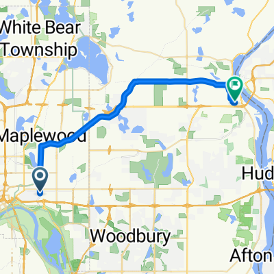
B2B00211 55119>55101 via Upper Afton, 7th Street
Cycling route in Maplewood, Minnesota, United States
- 17.8 km
- Distance
- 189 m
- Ascent
- 192 m
- Descent

Mississippi River Trail: Maplewood to Columbia Heights
Cycling route in Maplewood, Minnesota, United States
- 35.3 km
- Distance
- 256 m
- Ascent
- 222 m
- Descent

Maplewood Cycling
Cycling route in Maplewood, Minnesota, United States
- 14.1 km
- Distance
- 450 m
- Ascent
- 299 m
- Descent

Handsome Cycles
Cycling route in Maplewood, Minnesota, United States
- 38.6 km
- Distance
- 280 m
- Ascent
- 300 m
- Descent
Discover more routes
 B2B00784 55125>55164 via Up.Afton/Ruth/Mhaha/JohnsonPkwy/Wheelock/Edgerton/VadLake/Rice/Gramsie/Lex
- Distance
- 27.1 km
- Ascent
- 127 m
- Descent
- 137 m
- Location
- Maplewood, Minnesota, United States
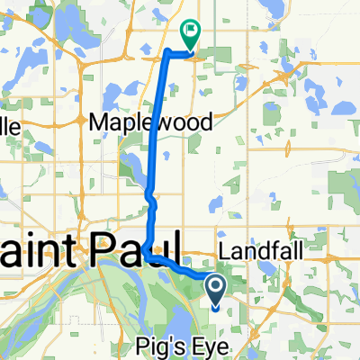
 B2B00182 55106 > 55101 vie Johnson Pkwy., Hudson, Kellogg
- Distance
- 6.5 km
- Ascent
- 46 m
- Descent
- 80 m
- Location
- Maplewood, Minnesota, United States
 B2B00497 55106>55082 via Bruce Vento Trl, Gateway Trl, Myrtle Av
- Distance
- 28.4 km
- Ascent
- 92 m
- Descent
- 89 m
- Location
- Maplewood, Minnesota, United States
 B2B00956 55119>55401 via Case Av, Como Av, 4th St SE
- Distance
- 24 km
- Ascent
- 159 m
- Descent
- 192 m
- Location
- Maplewood, Minnesota, United States
 B2B00758 55119>55128 viaUpperAfton/Century/HudsonRd./Hadley Hudson
- Distance
- 13.8 km
- Ascent
- 91 m
- Descent
- 78 m
- Location
- Maplewood, Minnesota, United States
 B2B00576 55119>55110 via Upper Afton Rd, Johnson Pkwy, Bruce Vento Trl
- Distance
- 17.1 km
- Ascent
- 74 m
- Descent
- 100 m
- Location
- Maplewood, Minnesota, United States
 B2B00401 55106>55454 via WheelockPkwy/Como/IntercampusTrail/27SE/Franklin/Riverside
- Distance
- 19.1 km
- Ascent
- 69 m
- Descent
- 71 m
- Location
- Maplewood, Minnesota, United States
 WB CTY PARK
- Distance
- 17.3 km
- Ascent
- 59 m
- Descent
- 71 m
- Location
- Maplewood, Minnesota, United States