
Cycling in Johnson
Discover a map of 66 cycling routes and bike trails near Johnson, created by our community.
Region portrait
Get to know Johnson
Find the right bike route for you through Johnson, where we've got 66 cycle routes to explore. Most people get on their bikes to ride here in the month of August.
2,126 km
Tracked distance
66
Cycle routes
1,443
Population


From our community
The best bike routes in and around Johnson
Cambridge Junction Road to Cambridge Junction Road
Cycling route in Johnson, Vermont, United States
- 28.4 km
- Distance
- 134 m
- Ascent
- 103 m
- Descent

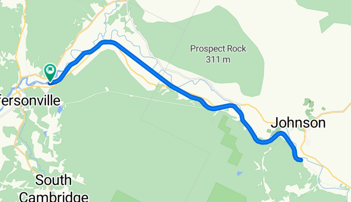
Jefferson - Stowe aller retour
Cycling route in Johnson, Vermont, United States
- 70.9 km
- Distance
- 1,554 m
- Ascent
- 1,523 m
- Descent

Col du Mont Mansfield, Vermont USA
Cycling route in Johnson, Vermont, United States
- 69.5 km
- Distance
- 1,086 m
- Ascent
- 1,083 m
- Descent

Smugglers Notch -Stowe retour par Stagecoach rd.
Cycling route in Johnson, Vermont, United States
- 69.2 km
- Distance
- 675 m
- Ascent
- 675 m
- Descent
Discover more routes
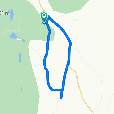 Route to Della Corte Road
- Distance
- 9.4 km
- Ascent
- 175 m
- Descent
- 150 m
- Location
- Johnson, Vermont, United States
 Jefferson, boucle supplémentaire
- Distance
- 11.1 km
- Ascent
- 181 m
- Descent
- 182 m
- Location
- Johnson, Vermont, United States
 Slow ride
- Distance
- 5.8 km
- Ascent
- 89 m
- Descent
- 109 m
- Location
- Johnson, Vermont, United States
 Della Corte Road 129, Eden to Della Corte Road 129, Eden
- Distance
- 2.4 km
- Ascent
- 77 m
- Descent
- 46 m
- Location
- Johnson, Vermont, United States
 Route from Della Corte Road 129, Eden
- Distance
- 2.1 km
- Ascent
- 59 m
- Descent
- 33 m
- Location
- Johnson, Vermont, United States
 Della Corte Road 129, Eden to Della Corte Road 129, Eden
- Distance
- 3.6 km
- Ascent
- 84 m
- Descent
- 57 m
- Location
- Johnson, Vermont, United States
 Della Corte Road 129, Eden to Della Corte Road 129, Eden
- Distance
- 2 km
- Ascent
- 37 m
- Descent
- 12 m
- Location
- Johnson, Vermont, United States
 Della Corte Road 129, Eden to Della Corte Road 129, Eden
- Distance
- 2.1 km
- Ascent
- 57 m
- Descent
- 27 m
- Location
- Johnson, Vermont, United States