
Cycling in Monte Sereno
Discover a map of 46 cycling routes and bike trails near Monte Sereno, created by our community.
Region portrait
Get to know Monte Sereno
Find the right bike route for you through Monte Sereno, where we've got 46 cycle routes to explore.
1,056 km
Tracked distance
46
Cycle routes
3,341
Population
Community
Most active users in Monte Sereno


From our community
The best bike routes in and around Monte Sereno

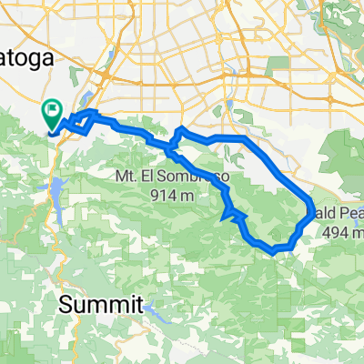
ride from Los Gatos to Saratoga
Cycling route in Monte Sereno, California, United States of America
- 13.1 km
- Distance
- 435 m
- Ascent
- 473 m
- Descent

Long bike tour through Los Gatos
Cycling route in Monte Sereno, California, United States of America
- 32.9 km
- Distance
- 238 m
- Ascent
- 237 m
- Descent

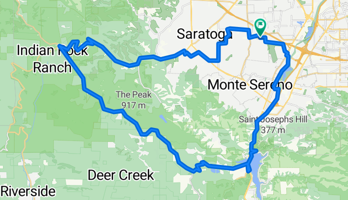
Long ride through Los Gatos
Cycling route in Monte Sereno, California, United States of America
- 34.1 km
- Distance
- 258 m
- Ascent
- 258 m
- Descent
creekTrail_upBlack,Gist->Skyline, north->9 &down
Cycling route in Monte Sereno, California, United States of America
- 48.9 km
- Distance
- 933 m
- Ascent
- 936 m
- Descent
Discover more routes
 Tour de California -Day 1 - LGS to HMB
- Distance
- 72.1 km
- Ascent
- 1,056 m
- Descent
- 1,115 m
- Location
- Monte Sereno, California, United States of America
 Los Gatos - Pasatiempo Inn
- Distance
- 59.6 km
- Ascent
- 1,044 m
- Descent
- 998 m
- Location
- Monte Sereno, California, United States of America
 41 Manzanita Ave, Los Gatos to 41 Manzanita Ave, Los Gatos
- Distance
- 34.8 km
- Ascent
- 1,300 m
- Descent
- 1,300 m
- Location
- Monte Sereno, California, United States of America
 Aquinas Trail, Los Gatos to 16515 Marchmont Dr, Los Gatos
- Distance
- 19.5 km
- Ascent
- 469 m
- Descent
- 706 m
- Location
- Monte Sereno, California, United States of America
 41 Manzanita Ave, Los Gatos to 41 Manzanita Ave, Los Gatos
- Distance
- 45.1 km
- Ascent
- 774 m
- Descent
- 773 m
- Location
- Monte Sereno, California, United States of America
 41 Manzanita Ave, Los Gatos to 121 Laurel Ave, Los Gatos
- Distance
- 0.4 km
- Ascent
- 30 m
- Descent
- 14 m
- Location
- Monte Sereno, California, United States of America
 16081–16099 Overlook Dr, Los Gatos to 41 Manzanita Ave, Los Gatos
- Distance
- 8.3 km
- Ascent
- 236 m
- Descent
- 413 m
- Location
- Monte Sereno, California, United States of America
 Hilly route to the east of LG
- Distance
- 54.4 km
- Ascent
- 667 m
- Descent
- 664 m
- Location
- Monte Sereno, California, United States of America