
Cycling in Tamalpais Valley
Discover a map of 18 cycling routes and bike trails near Tamalpais Valley, created by our community.
Region portrait
Get to know Tamalpais Valley
Find the right bike route for you through Tamalpais Valley, where we've got 18 cycle routes to explore.
516 km
Tracked distance
18
Cycle routes
7,000
Population
Community
Most active users in Tamalpais Valley


From our community
The best bike routes in and around Tamalpais Valley

GG bridge to Organic Cafe SF
Cycling route in Tamalpais Valley, California, United States
- 18.7 km
- Distance
- 181 m
- Ascent
- 244 m
- Descent

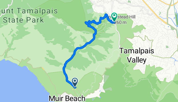
Muir Beach to Mount Tamalpais
Cycling route in Tamalpais Valley, California, United States
20ish mile route on Mt. Tam. Starts at Muir Beach Overlook and works its way up to the top of Tam, and then back down. Great views (when it isn't foggy).
- 30.5 km
- Distance
- 865 m
- Ascent
- 865 m
- Descent
muir woods rd
Cycling route in Tamalpais Valley, California, United States
distance: 3.927 miles
<br />start: 22'
<br />end: 718'
<br />net gain: 696'
<br />gradient: 3.4%
- 6.3 km
- Distance
- 358 m
- Ascent
- 160 m
- Descent

Century Ride #3
Cycling route in Tamalpais Valley, California, United States
- 165.3 km
- Distance
- 950 m
- Ascent
- 1,025 m
- Descent
Discover more routes
 Pirates Cove Trail, Mill Valley to 15 Corte Del Coronado, Larkspur
- Distance
- 16.6 km
- Ascent
- 165 m
- Descent
- 336 m
- Location
- Tamalpais Valley, California, United States
 Muir Beach to Muir Wood (as walked)
- Distance
- 30.4 km
- Ascent
- 805 m
- Descent
- 805 m
- Location
- Tamalpais Valley, California, United States
 Sunday 11/17/24
- Distance
- 13.4 km
- Ascent
- 528 m
- Descent
- 525 m
- Location
- Tamalpais Valley, California, United States
 1017 Melaleuca Ln, Tamalpais to 1017 Melaleuca Ln, Tamalpais
- Distance
- 17 km
- Ascent
- 82 m
- Descent
- 193 m
- Location
- Tamalpais Valley, California, United States
 canopy trail Mill Valley
- Distance
- 5.6 km
- Ascent
- 388 m
- Descent
- 372 m
- Location
- Tamalpais Valley, California, United States
 1008 Erica Rd, Tamalpais to 1030 Erica Rd, Tamalpais
- Distance
- 30.4 km
- Ascent
- 855 m
- Descent
- 890 m
- Location
- Tamalpais Valley, California, United States
 Muir to San Fran
- Distance
- 30.2 km
- Ascent
- 646 m
- Descent
- 702 m
- Location
- Tamalpais Valley, California, United States
 From Muir woods to Tomales
- Distance
- 114.2 km
- Ascent
- 912 m
- Descent
- 912 m
- Location
- Tamalpais Valley, California, United States