
Cycling in Sheridan
Discover a map of 101 cycling routes and bike trails near Sheridan, created by our community.
Region portrait
Get to know Sheridan
Find the right bike route for you through Sheridan, where we've got 101 cycle routes to explore. Most people get on their bikes to ride here in the months of June and July.
3,216 km
Tracked distance
101
Cycle routes
5,664
Population
Community
Most active users in Sheridan


From our community
The best bike routes in and around Sheridan

bear creek 470
Cycling route in Sheridan, Colorado, United States of America
- 50.5 km
- Distance
- 285 m
- Ascent
- 285 m
- Descent

Easy ride in Englewood
Cycling route in Sheridan, Colorado, United States of America
- 5.9 km
- Distance
- 52 m
- Ascent
- 69 m
- Descent

PICU Peloton Bear Creek Lake Park Loop
Cycling route in Sheridan, Colorado, United States of America
- 51.3 km
- Distance
- 410 m
- Ascent
- 408 m
- Descent

3208 S Patton Ct, Denver to 2554 S Broadway, Denver
Cycling route in Sheridan, Colorado, United States of America
- 8 km
- Distance
- 20 m
- Ascent
- 55 m
- Descent
Discover more routes
 River Point Parkway 3602, Sheridan to River Point Parkway 3602, Sheridan
- Distance
- 27.2 km
- Ascent
- 95 m
- Descent
- 82 m
- Location
- Sheridan, Colorado, United States of America
 Bear Creek Trail (Sheridan - Bear Creek Lake)
- Distance
- 36.8 km
- Ascent
- 375 m
- Descent
- 376 m
- Location
- Sheridan, Colorado, United States of America
 Estes/Winter Park Loop
- Distance
- 378.2 km
- Ascent
- 7,606 m
- Descent
- 7,561 m
- Location
- Sheridan, Colorado, United States of America
 Slow ride in Denver
- Distance
- 0.6 km
- Ascent
- 8 m
- Descent
- 4 m
- Location
- Sheridan, Colorado, United States of America
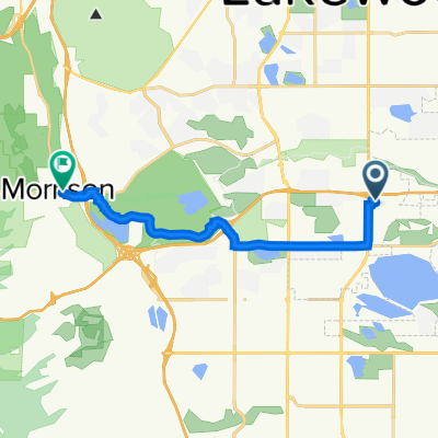 West Jefferson Avenue 7393, Lakewood to Bear Creek Avenue 117, Morrison
- Distance
- 12.7 km
- Ascent
- 195 m
- Descent
- 101 m
- Location
- Sheridan, Colorado, United States of America
 West Dartmouth Avenue 6990, Denver to South Valley Road, Littleton
- Distance
- 40 km
- Ascent
- 437 m
- Descent
- 270 m
- Location
- Sheridan, Colorado, United States of America
 Finish up SW Denver - Bike Map Quest
- Distance
- 27 km
- Ascent
- 126 m
- Descent
- 125 m
- Location
- Sheridan, Colorado, United States of America
 Sawyer Walk
- Distance
- 4.9 km
- Ascent
- 28 m
- Descent
- 27 m
- Location
- Sheridan, Colorado, United States of America