


Cycling in Troutdale
Discover a map of 68 cycling routes and bike trails near Troutdale, created by our community.
Region portrait
Get to know Troutdale
Find the right bike route for you through Troutdale, where we've got 68 cycle routes to explore. Most people get on their bikes to ride here in the month of October.
2,735 km
Tracked distance
68
Cycle routes
15,962
Population
Community
Most active users in Troutdale
From our community
The best bike routes in and around Troutdale
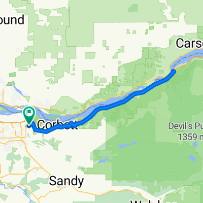
SW Lancaster Ct, Troutdale to NE Liberty Ave, Gresham
Cycling route in Troutdale, Oregon, United States
- 7.2 km
- Distance
- 97 m
- Ascent
- 22 m
- Descent
Easy ride in Troutdale
Cycling route in Troutdale, Oregon, United States
- 7.7 km
- Distance
- 4 m
- Ascent
- 4 m
- Descent
Easy ride in Troutdale
Cycling route in Troutdale, Oregon, United States
- 8.1 km
- Distance
- 36 m
- Ascent
- 36 m
- Descent
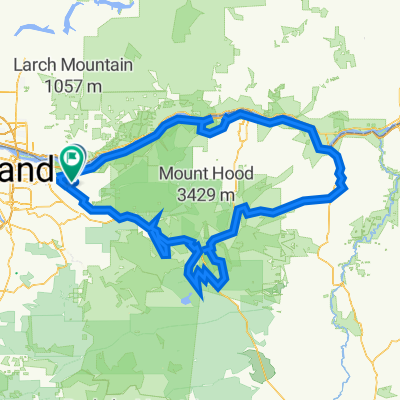
corbett farmland
Cycling route in Troutdale, Oregon, United States
- 20 km
- Distance
- 398 m
- Ascent
- 428 m
- Descent
Discover more routes
- All routes in Troutdale
- Round trips
- Relaxed
- Gravel
- Road
- MTB
- Trekking

 Southeast Gordon Creek Road 36205, Corbett to Sunset Road 1210, Hood River1
- 81.9 km
- 1,234 m
- 1,137 m
- Troutdale, Oregon, United States
 East Columbia River Highway 167, Troutdale to Southeast Rickert Road 36334, Corbett1
- 16.5 km
- 282 m
- 177 m
- Troutdale, Oregon, United States

 Columbia River Historic Highway - Troutdale to Cascade Locks0
- 101.1 km
- 922 m
- 922 m
- Troutdale, Oregon, United States
 31815 Historic Columbia River Hwy, Troutdale to 3110 NE 111th Dr, Portland0
- 67.4 km
- 47 m
- 127 m
- Troutdale, Oregon, United States

 FPW6+82V, Corbett to Southeast Oxbow Park Road 4817-3435, Gresham0
- 435.4 km
- 13,590 m
- 13,583 m
- Troutdale, Oregon, United States


