
Cycling in Tulgheş
Discover a map of 75 cycling routes and bike trails near Tulgheş, created by our community.
Region portrait
Get to know Tulgheş
Find the right bike route for you through Tulgheş, where we've got 75 cycle routes to explore. Most people get on their bikes to ride here in the month of July.
7,570 km
Tracked distance
75
Cycle routes
3,543
Population
Community
Most active users in Tulgheş


From our community
The best bike routes in and around Tulgheş
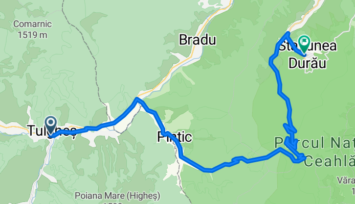
From Tulgheș to Ceahlău
Cycling route in Tulgheş, Harghita County, Romania
- 27.8 km
- Distance
- 1,014 m
- Ascent
- 869 m
- Descent

Tulghes- Creanga - Creasta Creanga-Tengheler ( atentie la traseu)
Cycling route in Tulgheş, Harghita County, Romania
- 73.8 km
- Distance
- 1,104 m
- Ascent
- 1,101 m
- Descent

De 2x la Vf Highes
Cycling route in Tulgheş, Harghita County, Romania
- 47.4 km
- Distance
- 1,374 m
- Ascent
- 1,373 m
- Descent

Lacul Cuejdel & Muntii Stânișoarei
Cycling route in Tulgheş, Harghita County, Romania
- 169.9 km
- Distance
- 1,722 m
- Ascent
- 1,715 m
- Descent
Discover more routes
 ziua 4 tulghes damuc paltinis ciuc
- Distance
- 71.8 km
- Ascent
- 1,211 m
- Descent
- 984 m
- Location
- Tulgheş, Harghita County, Romania
 Vârful Prișca
- Distance
- 70.7 km
- Ascent
- 1,640 m
- Descent
- 1,647 m
- Location
- Tulgheş, Harghita County, Romania
 Valea Bistritei-TransRarău-Mestecănis-Bilbor
- Distance
- 288.7 km
- Ascent
- 2,307 m
- Descent
- 2,317 m
- Location
- Tulgheş, Harghita County, Romania
 Drumul Baltagului
- Distance
- 150 km
- Ascent
- 1,458 m
- Descent
- 1,467 m
- Location
- Tulgheş, Harghita County, Romania
 Munții Bistriței Tour
- Distance
- 127.4 km
- Ascent
- 1,772 m
- Descent
- 1,768 m
- Location
- Tulgheş, Harghita County, Romania
 (23.09.2017) Tulghes - Pintic - Vf. Poiana Mare - Pasul Balaj - Tulghes
- Distance
- 33.2 km
- Ascent
- 1,014 m
- Descent
- 1,010 m
- Location
- Tulgheş, Harghita County, Romania
 Hagoto - Vithavas alatt - Pongratz teto - Nagyhagymas gerinc
- Distance
- 34.9 km
- Ascent
- 1,432 m
- Descent
- 719 m
- Location
- Tulgheş, Harghita County, Romania
 Bicazu Ardelean - Borsec
- Distance
- 82 km
- Ascent
- 1,134 m
- Descent
- 1,341 m
- Location
- Tulgheş, Harghita County, Romania