
Cycling in 23 August
Discover a map of 49 cycling routes and bike trails near 23 August, created by our community.
Region portrait
Get to know 23 August
Find the right bike route for you through 23 August, where we've got 49 cycle routes to explore. Most people get on their bikes to ride here in the months of July and August.
3,310 km
Tracked distance
49
Cycle routes
2,849
Population
Community
Most active users in 23 August


From our community
The best bike routes in and around 23 August


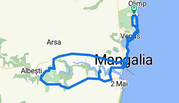
Strada Trandafirilor, Mangalia to Strada Trandafirilor, Mangalia
Cycling route in 23 August, Constanța County, Romania
- 52.5 km
- Distance
- 318 m
- Ascent
- 318 m
- Descent


Strada Trandafirilor, Mangalia to Strada Trandafirilor, Mangalia
Cycling route in 23 August, Constanța County, Romania
- 55.3 km
- Distance
- 326 m
- Ascent
- 326 m
- Descent


Hotel Amfiteatru-Mangalia-Limanu-Hagieni-Arsa-Pecineaga-23August-Hotel Amfiteatru
Cycling route in 23 August, Constanța County, Romania
- 55.7 km
- Distance
- 344 m
- Ascent
- 344 m
- Descent


hotel Amfiteatru Olimp-Mangalia și retur
Cycling route in 23 August, Constanța County, Romania
- 26.6 km
- Distance
- 100 m
- Ascent
- 101 m
- Descent
Discover more routes
 Camino Litoral Marea Neagră
- Distance
- 44.8 km
- Ascent
- 168 m
- Descent
- 170 m
- Location
- 23 August, Constanța County, Romania
 Olimp - 23 August - Costinesti - Tuzla - Eforie Sud - Eforie Nord
- Distance
- 29.2 km
- Ascent
- 132 m
- Descent
- 133 m
- Location
- 23 August, Constanța County, Romania
 olimp mangalia
- Distance
- 24.8 km
- Ascent
- 94 m
- Descent
- 93 m
- Location
- 23 August, Constanța County, Romania
 Neptun - Mangalia
- Distance
- 23.5 km
- Ascent
- 104 m
- Descent
- 107 m
- Location
- 23 August, Constanța County, Romania
 tura de vacanta 2019 Olimp
- Distance
- 127 km
- Ascent
- 288 m
- Descent
- 288 m
- Location
- 23 August, Constanța County, Romania
 Strada Gării 1, Neptun to Strada Ion Creangă Nr 2, Vama Veche
- Distance
- 18.1 km
- Ascent
- 128 m
- Descent
- 136 m
- Location
- 23 August, Constanța County, Romania
 Sea Aude Ride
- Distance
- 36.4 km
- Ascent
- 137 m
- Descent
- 137 m
- Location
- 23 August, Constanța County, Romania
 DN39 78, 23 August to Strada Mihai Viteazu 18, Mangalia
- Distance
- 15.6 km
- Ascent
- 49 m
- Descent
- 87 m
- Location
- 23 August, Constanța County, Romania