
Cycling in Sajóbábony
Discover a map of 320 cycling routes and bike trails near Sajóbábony, created by our community.
Region portrait
Get to know Sajóbábony
Find the right bike route for you through Sajóbábony, where we've got 320 cycle routes to explore. Most people get on their bikes to ride here in the months of July and August.
14,715 km
Tracked distance
320
Cycle routes
3,113
Population
Community
Most active users in Sajóbábony


Handpicked routes
Discover Sajóbábony through these collections
Tour
From our community
The best bike routes in and around Sajóbábony


2019 első
Cycling route in Sajóbábony, Borsod-Abauj Zemplen county, Hungary
- 28.9 km
- Distance
- 1,450 m
- Ascent
- 1,510 m
- Descent

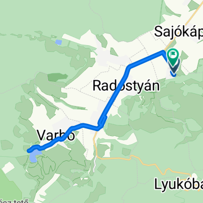
Lillafüred kiskör
Cycling route in Sajóbábony, Borsod-Abauj Zemplen county, Hungary
Lillafüred-Fehér-kő lápa-Bükkszentkereszt-Hollóstető-Lillafüred
- 15.9 km
- Distance
- 528 m
- Ascent
- 543 m
- Descent


Erzsébet sétány 8, Miskolc to Egri Országút 3517, Miskolc
Cycling route in Sajóbábony, Borsod-Abauj Zemplen county, Hungary
- 34.4 km
- Distance
- 1,572 m
- Ascent
- 1,606 m
- Descent
![OFFICAL[80] Bükki Kerékpáros Teljesítménytúra 80KM](https://media.bikemap.net/routes/5232348/staticmaps/in_c4928604-e229-4de7-b8b3-453c794c17ea_694x400_bikemap-2021-3D-static.png)
OFFICAL[80] Bükki Kerékpáros Teljesítménytúra 80KM
Cycling route in Sajóbábony, Borsod-Abauj Zemplen county, Hungary
Királyasztal – Alsóhámor – Felsőhámor – Hámori-tó – Savós völgy – Létrás-tető – Jávorkút – Nagymező – Olasz kapu – Gerenna vár - Tótfalu völgy – Szilvásvárad – Nagyvisnyó – Dédestapolcsány – Mályinka - Kerek hegy – Szentlélek - Csókás – Őskohó - Hámori tó – Felsőhámor – Alsóhámor – Királyasztal
Táv: 80,1 km Szintemelkedés: 1325 m Szintidő: 7 óra Indítás: 8.00-10.00 óra között
Nevezési díj: 1300/1600 Ft (előnevezés/helyszíni nevezés)
- 75.4 km
- Distance
- 2,949 m
- Ascent
- 2,950 m
- Descent
Discover more routes
 Bükki teljesítménytúra - Autómentes nap 2015
- Distance
- 114.9 km
- Ascent
- 1,496 m
- Descent
- 1,497 m
- Location
- Sajóbábony, Borsod-Abauj Zemplen county, Hungary
 Lillafüred - Eger
- Distance
- 47.3 km
- Ascent
- 488 m
- Descent
- 627 m
- Location
- Sajóbábony, Borsod-Abauj Zemplen county, Hungary
 Miskolc - Árpád utca, Miskolc
- Distance
- 3.9 km
- Ascent
- 55 m
- Descent
- 141 m
- Location
- Sajóbábony, Borsod-Abauj Zemplen county, Hungary
 Bükk teljesítménytúra 50km
- Distance
- 47.5 km
- Ascent
- 671 m
- Descent
- 672 m
- Location
- Sajóbábony, Borsod-Abauj Zemplen county, Hungary
 Pisztrángozós
- Distance
- 27.7 km
- Ascent
- 886 m
- Descent
- 889 m
- Location
- Sajóbábony, Borsod-Abauj Zemplen county, Hungary
 Hunyadi János utca, Sajólászlófalva - Rákóczi Ferenc utca, Sajólászlófalva
- Distance
- 14.9 km
- Ascent
- 85 m
- Descent
- 86 m
- Location
- Sajóbábony, Borsod-Abauj Zemplen county, Hungary
 Lillafüred-Bükkfennsík-Lillafüred
- Distance
- 36.9 km
- Ascent
- 920 m
- Descent
- 769 m
- Location
- Sajóbábony, Borsod-Abauj Zemplen county, Hungary
 Települések 2021.
- Distance
- 16.6 km
- Ascent
- 177 m
- Descent
- 406 m
- Location
- Sajóbábony, Borsod-Abauj Zemplen county, Hungary
Routes from Sajóbábony
Cycling day trip from
Sajóbábony to Szilvásvárad
Routes to Sajóbábony
Quick ride by bicycle from
Miskolc to Sajóbábony