
Cycling in Lagunitas-Forest Knolls
Discover a map of 50 cycling routes and bike trails near Lagunitas-Forest Knolls, created by our community.
Region portrait
Get to know Lagunitas-Forest Knolls
Find the right bike route for you through Lagunitas-Forest Knolls, where we've got 50 cycle routes to explore.
2,477 km
Tracked distance
50
Cycle routes
1,819
Population
Community
Most active users in Lagunitas-Forest Knolls


From our community
The best bike routes in and around Lagunitas-Forest Knolls

Nicasio Olema Loop enduro
Cycling route in Lagunitas-Forest Knolls, California, United States
- 34.8 km
- Distance
- 371 m
- Ascent
- 367 m
- Descent

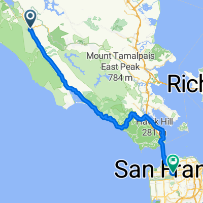
Bolinas Ridge to Hawk Camp
Cycling route in Lagunitas-Forest Knolls, California, United States
Park just north of Samuel P. taylor and take Bolinas Ridge into Mt. Tamapaias and over to the Marin headlands ending at Hawk campground
- 46.7 km
- Distance
- 1,534 m
- Ascent
- 1,342 m
- Descent
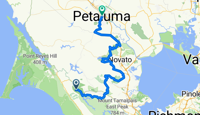
BART: Sam Taylor to Petaluma
Cycling route in Lagunitas-Forest Knolls, California, United States
Some variation from CN route near Mt Burdell. Does not include Indian Tree climb (O/B).
- 79.3 km
- Distance
- 2,441 m
- Ascent
- 2,505 m
- Descent

nicasio - bolinas - panoramic loop
Cycling route in Lagunitas-Forest Knolls, California, United States
Hilly and beautiful ride in Marin.
climbs of note:
(1) nicasio valley rd
(2) bolinas-fairfax rd (from fairfax)
(3) panoramic highway/pantoll (from stinson beach)
(4) bo-fax back to fairfax (from alpine lake)
(5) white's grade
(6) nicasio valley rd
- 93.5 km
- Distance
- 1,489 m
- Ascent
- 1,489 m
- Descent
Discover more routes
 Nicasio to Kehoe and back
- Distance
- 72.1 km
- Ascent
- 478 m
- Descent
- 475 m
- Location
- Lagunitas-Forest Knolls, California, United States
 TT course #2
- Distance
- 10.1 km
- Ascent
- 84 m
- Descent
- 131 m
- Location
- Lagunitas-Forest Knolls, California, United States
 9.94mi Nicasio to Pt Reyes Station 1-way
- Distance
- 16 km
- Ascent
- 90 m
- Descent
- 140 m
- Location
- Lagunitas-Forest Knolls, California, United States
 Brake for Nicasio
- Distance
- 34.3 km
- Ascent
- 437 m
- Descent
- 441 m
- Location
- Lagunitas-Forest Knolls, California, United States
 7/29/23 - 2.5hr loop
- Distance
- 70.9 km
- Ascent
- 917 m
- Descent
- 919 m
- Location
- Lagunitas-Forest Knolls, California, United States
 Olema to home
- Distance
- 59.3 km
- Ascent
- 856 m
- Descent
- 808 m
- Location
- Lagunitas-Forest Knolls, California, United States
 half moon bay
- Distance
- 94.9 km
- Ascent
- 726 m
- Descent
- 769 m
- Location
- Lagunitas-Forest Knolls, California, United States
 Olema Loop
- Distance
- 81.5 km
- Ascent
- 520 m
- Descent
- 522 m
- Location
- Lagunitas-Forest Knolls, California, United States