
Cycling in San Bernardo
Discover a map of 40 cycling routes and bike trails near San Bernardo, created by our community.
Region portrait
Get to know San Bernardo
Find the right bike route for you through San Bernardo, where we've got 40 cycle routes to explore.
2,248 km
Tracked distance
40
Cycle routes
323
Population
Community
Most active users in San Bernardo


From our community
The best bike routes in and around San Bernardo

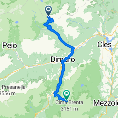
Transalp Etappe 6
Cycling route in San Bernardo, Trentino-Alto Adige, Italy
- 43.6 km
- Distance
- 1,739 m
- Ascent
- 1,728 m
- Descent

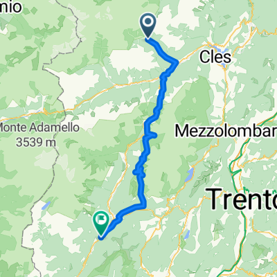
Haselgruber Hütte - Rifugio Ghedina
Cycling route in San Bernardo, Trentino-Alto Adige, Italy
- 70.2 km
- Distance
- 1,705 m
- Ascent
- 3,017 m
- Descent

12 part 5/6 st. gertraud >>> refugio graffer
Cycling route in San Bernardo, Trentino-Alto Adige, Italy
- 52.6 km
- Distance
- 2,549 m
- Ascent
- 1,713 m
- Descent

VIA DELLE MALGHE NEL PARCO NAZIONALE DELLO STELVIO
Cycling route in San Bernardo, Trentino-Alto Adige, Italy
- 28.2 km
- Distance
- 1,271 m
- Ascent
- 1,271 m
- Descent
Discover more routes
 ALLE CASCATE DI VALORZ (VAL DE L’ORS)
- Distance
- 5.2 km
- Ascent
- 268 m
- Descent
- 268 m
- Location
- San Bernardo, Trentino-Alto Adige, Italy
 Trans Alp 2013 - Psycho Cross - Etappe 6
- Distance
- 73.7 km
- Ascent
- 1,473 m
- Descent
- 2,084 m
- Location
- San Bernardo, Trentino-Alto Adige, Italy
 ritorno migliore
- Distance
- 156.4 km
- Ascent
- 1,849 m
- Descent
- 2,276 m
- Location
- San Bernardo, Trentino-Alto Adige, Italy
 Transalp 2015 Etappe 6 real.gpx
- Distance
- 49.5 km
- Ascent
- 1,648 m
- Descent
- 1,812 m
- Location
- San Bernardo, Trentino-Alto Adige, Italy
 Trek dello Stelvio tappa 1
- Distance
- 6.4 km
- Ascent
- 952 m
- Descent
- 0 m
- Location
- San Bernardo, Trentino-Alto Adige, Italy
 2018 Tag 2-1
- Distance
- 77.3 km
- Ascent
- 1,915 m
- Descent
- 2,253 m
- Location
- San Bernardo, Trentino-Alto Adige, Italy
 Tag 5.
- Distance
- 76.5 km
- Ascent
- 1,093 m
- Descent
- 1,517 m
- Location
- San Bernardo, Trentino-Alto Adige, Italy
 AlpenX2017_Etappe5
- Distance
- 49.5 km
- Ascent
- 1,887 m
- Descent
- 1,887 m
- Location
- San Bernardo, Trentino-Alto Adige, Italy