
Cycling in Randolph Township
Discover a map of 23 cycling routes and bike trails near Randolph Township, created by our community.
Region portrait
Get to know Randolph Township
Find the right bike route for you through Randolph Township, where we've got 23 cycle routes to explore.
323 km
Tracked distance
23
Cycle routes
25,734
Population
Community
Most active users in Randolph Township


From our community
The best bike routes in and around Randolph Township

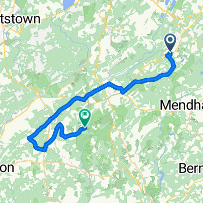
312 Quaker Church Rd, Randolph to 36 Prospect St, Dover
Cycling route in Randolph Township, New Jersey, United States
- 5.8 km
- Distance
- 69 m
- Ascent
- 160 m
- Descent

Freedom Trail
Cycling route in Randolph Township, New Jersey, United States
- 4.8 km
- Distance
- 118 m
- Ascent
- 122 m
- Descent

667 Millbrook Ave, Randolph to 667 Millbrook Ave, Randolph
Cycling route in Randolph Township, New Jersey, United States
- 7.7 km
- Distance
- 158 m
- Ascent
- 162 m
- Descent

1204 Sussex Tpke, Randolph to 1088 US-46 W, Parsippany
Cycling route in Randolph Township, New Jersey, United States
- 19.8 km
- Distance
- 119 m
- Ascent
- 336 m
- Descent
Discover more routes
 Route to 667 Millbrook Ave, Randolph
- Distance
- 5.6 km
- Ascent
- 142 m
- Descent
- 139 m
- Location
- Randolph Township, New Jersey, United States
 30–98 Marjaleen Dr, Randolph to 104 State Park Rd, Chester
- Distance
- 13.4 km
- Ascent
- 125 m
- Descent
- 208 m
- Location
- Randolph Township, New Jersey, United States
 Tom to cidermill
- Distance
- 29.3 km
- Ascent
- 261 m
- Descent
- 349 m
- Location
- Randolph Township, New Jersey, United States
 126 South Rd, Mendham to 9 Revere Ct, Randolph
- Distance
- 7.4 km
- Ascent
- 83 m
- Descent
- 69 m
- Location
- Randolph Township, New Jersey, United States
 Route from 342 Quaker Church Rd, Randolph
- Distance
- 25.9 km
- Ascent
- 435 m
- Descent
- 540 m
- Location
- Randolph Township, New Jersey, United States
 First Route
- Distance
- 10.1 km
- Ascent
- 152 m
- Descent
- 152 m
- Location
- Randolph Township, New Jersey, United States
 Route to 667 Millbrook Ave, Randolph
- Distance
- 4.6 km
- Ascent
- 101 m
- Descent
- 81 m
- Location
- Randolph Township, New Jersey, United States
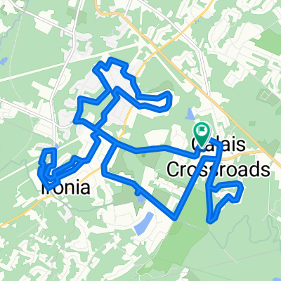 Heritage Court, Heinstein Park, Ironia, Pleasant Hill
- Distance
- 21.5 km
- Ascent
- 391 m
- Descent
- 396 m
- Location
- Randolph Township, New Jersey, United States