
Route template
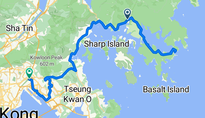
Sai Kung to Kowloon

- 4 h 1 min
- Duration
- 42.9 km
- Distance
- 1,470 m
- Ascent
- 1,458 m
- Descent
- 10.7 km/h
- Avg. speed
- 439 m
- Max. altitude
This cycling route takes you from the scenic coastal town of Sai Kung all the way into the heart of Kowloon. Starting in Sai Kung, known for its seafood restaurants and laid-back vibes, you’ll wind your way through a mix of quiet backroads and more bustling urban stretches. The route covers just under 43 km and packs in over 1,400 meters of climbing, so get ready for a few solid hills—one even climbs up to over 430 meters!
You'll get a little bit of everything along the way: about half the surface is paved, though some segments are missing details—so double-check for any off-the-map sections. Most of your cycling will be on peaceful roads, but there are a few busier stretches as you edge closer to Kowloon, so stay alert.
Finishing in Kowloon, you’ll find yourself surrounded by vibrant food markets, bustling streets, and skyscrapers—a striking contrast to Sai Kung’s calm waters. This ride offers a great sampler of Hong Kong’s diversity, both in scenery and cycling challenge!
Community
Top users in this region


From our community
The best bike routes from Sai Kung to Kowloon
大網仔路, 西貢 to 沐翠街3號, 啟德
Cycling route in Sai Kung, Sai Kung District, Hong Kong
- 49.1 km
- Distance
- 937 m
- Ascent
- 878 m
- Descent

將軍澳 往返 康城 (經:坑口北)
Cycling route in Sai Kung, Sai Kung District, Hong Kong
- 8.6 km
- Distance
- 98 m
- Ascent
- 120 m
- Descent

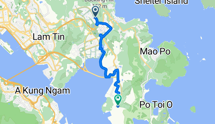
hang hau - rennie's mill - sau mau ping
Cycling route in Sai Kung, Sai Kung District, Hong Kong
- 6 km
- Distance
- 253 m
- Ascent
- 147 m
- Descent

20170625飛鵝山
Cycling route in Sai Kung, Sai Kung District, Hong Kong
- 25.4 km
- Distance
- 705 m
- Ascent
- 701 m
- Descent

Wan Hang Rd, Tseung Kwan O to 1 Lohas Park Rd, Tseung Kwan O
Cycling route in Sai Kung, Sai Kung District, Hong Kong
- 5.7 km
- Distance
- 460 m
- Ascent
- 444 m
- Descent

大囲−ホンハム20180318
Cycling route in Sai Kung, Sai Kung District, Hong Kong
- 30.2 km
- Distance
- 836 m
- Ascent
- 793 m
- Descent


Po Fung Road, Tseung Kwan O to Zebra crossing between Po Yap Road, Tseung Kwan O
Cycling route in Sai Kung, Sai Kung District, Hong Kong
- 3 km
- Distance
- 289 m
- Ascent
- 362 m
- Descent

Wan Po Road, Tseung Kwan O to Tseung Kwan O South Waterfront Promenade, Tseung Kwan O
Cycling route in Sai Kung, Sai Kung District, Hong Kong
- 2.9 km
- Distance
- 31 m
- Ascent
- 40 m
- Descent


庇利街到海下灣
Cycling route in Sai Kung, Sai Kung District, Hong Kong
- 33.7 km
- Distance
- 599 m
- Ascent
- 592 m
- Descent
Discover more routes
 20170625飛鵝山
- Distance
- 25.4 km
- Ascent
- 705 m
- Descent
- 701 m
- Location
- Sai Kung, Sai Kung District, Hong Kong
 Wan Hang Rd, Tseung Kwan O to 1 Lohas Park Rd, Tseung Kwan O
- Distance
- 5.7 km
- Ascent
- 460 m
- Descent
- 444 m
- Location
- Sai Kung, Sai Kung District, Hong Kong
 大囲−ホンハム20180318
- Distance
- 30.2 km
- Ascent
- 836 m
- Descent
- 793 m
- Location
- Sai Kung, Sai Kung District, Hong Kong
 Easy ride
- Distance
- 7.8 km
- Ascent
- 88 m
- Descent
- 99 m
- Location
- Sai Kung, Sai Kung District, Hong Kong
 Po Fung Road, Tseung Kwan O to Zebra crossing between Po Yap Road, Tseung Kwan O
- Distance
- 3 km
- Ascent
- 289 m
- Descent
- 362 m
- Location
- Sai Kung, Sai Kung District, Hong Kong
 Wan Po Road, Tseung Kwan O to Tseung Kwan O South Waterfront Promenade, Tseung Kwan O
- Distance
- 2.9 km
- Ascent
- 31 m
- Descent
- 40 m
- Location
- Sai Kung, Sai Kung District, Hong Kong
 試驗2
試驗2- Distance
- 24.9 km
- Ascent
- 666 m
- Descent
- 646 m
- Location
- Sai Kung, Sai Kung District, Hong Kong
 庇利街到海下灣
- Distance
- 33.7 km
- Ascent
- 599 m
- Descent
- 592 m
- Location
- Sai Kung, Sai Kung District, Hong Kong
Routes from Sai Kung
Cycling day trip from
Sai Kung to Tai Po
Cycling day trip from
Sai Kung to Shatin