
By bicycle from Nauders to Graun im Vinschgau
Customize your own route based on our template or discover how our community prefers to cycle from Nauders to Graun im Vinschgau.
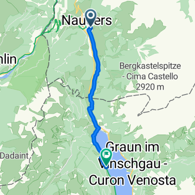
Route template
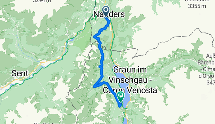
Nauders to Graun im Vinschgau

- 49 min
- Duration
- 13.4 km
- Distance
- 293 m
- Ascent
- 258 m
- Descent
- 16.5 km/h
- Avg. speed
- 1,533 m
- Max. altitude
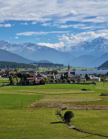
Looking for a stunning cross-border ride with alpine views? This route from Nauders to Graun im Vinschgau is a classic! Starting in Nauders, a charming Austrian village nestled at the Reschen Pass, you’ll cruise along mostly quiet, paved roads with a bit of easy gravel and unpaved stretches to keep things interesting. The route takes you 13.4 km south, winding through high mountain scenery and past picturesque alpine meadows.
You’ll gain almost 300 meters in elevation, but nothing too punishing, and you’ll enjoy a similar descent as you swoop down towards Italy. The real highlight comes as you approach Graun im Vinschgau—famous for the haunting bell tower rising from Lake Reschen, a reminder of the old village flooded for the reservoir.
Both towns are steeped in Tyrolean culture, with plenty of traditional food waiting at either end. It’s the perfect short ride for anyone wanting a taste of the Alps and a bit of history. Don’t forget your camera!
Community
Top users in this region


From our community
The best bike routes from Nauders to Graun im Vinschgau


Plamort Trail
Cycling route in Nauders, Tyrol, Austria
- 5.5 km
- Distance
- 58 m
- Ascent
- 672 m
- Descent

1a. Et Nauders -Reschensee
Cycling route in Nauders, Tyrol, Austria
- 7.3 km
- Distance
- 221 m
- Ascent
- 84 m
- Descent

Reschenseerunde von Nauders
Cycling route in Nauders, Tyrol, Austria
- 37.4 km
- Distance
- 951 m
- Ascent
- 780 m
- Descent

CA6 Nauders (Austria) to San Valentino (Italy)
Cycling route in Nauders, Tyrol, Austria
- 17.5 km
- Distance
- 242 m
- Ascent
- 162 m
- Descent
Fimberpass - Val d'Uina - Reschenpass: Nauders - Graun im Vinschgau
Cycling route in Nauders, Tyrol, Austria
- 21.1 km
- Distance
- 1,224 m
- Ascent
- 945 m
- Descent


20150817_090406.gpx
Cycling route in Nauders, Tyrol, Austria
- 18.6 km
- Distance
- 791 m
- Ascent
- 660 m
- Descent


Plamorttrail Reschen
Cycling route in Nauders, Tyrol, Austria
- 1.5 km
- Distance
- 39 m
- Ascent
- 57 m
- Descent

BSG-2013 Nauders=> 1.Etappe
Cycling route in Nauders, Tyrol, Austria
- 17 km
- Distance
- 0 m
- Ascent
- 0 m
- Descent

Plamortboden mit Aufstiegshilfe
Cycling route in Nauders, Tyrol, Austria
- 7.8 km
- Distance
- 194 m
- Ascent
- 838 m
- Descent
Discover more routes
 Fimberpass - Val d'Uina - Reschenpass: Nauders - Graun im Vinschgau
- Distance
- 21.1 km
- Ascent
- 1,224 m
- Descent
- 945 m
- Location
- Nauders, Tyrol, Austria
 nauders
- Distance
- 274 km
- Ascent
- 11,214 m
- Descent
- 11,086 m
- Location
- Nauders, Tyrol, Austria
 20150817_090406.gpx
- Distance
- 18.6 km
- Ascent
- 791 m
- Descent
- 660 m
- Location
- Nauders, Tyrol, Austria
 Tag zwei b
- Distance
- 19.9 km
- Ascent
- 634 m
- Descent
- 1,008 m
- Location
- Nauders, Tyrol, Austria
 Plamorttrail Reschen
- Distance
- 1.5 km
- Ascent
- 39 m
- Descent
- 57 m
- Location
- Nauders, Tyrol, Austria
 BSG-2013 Nauders=> 1.Etappe
- Distance
- 17 km
- Ascent
- 0 m
- Descent
- 0 m
- Location
- Nauders, Tyrol, Austria
 Plamortboden mit Aufstiegshilfe
- Distance
- 7.8 km
- Ascent
- 194 m
- Descent
- 838 m
- Location
- Nauders, Tyrol, Austria
 Nauders - Graun
- Distance
- 10.2 km
- Ascent
- 308 m
- Descent
- 161 m
- Location
- Nauders, Tyrol, Austria
Routes from Nauders
Bikepacking from
Nauders to Verona
Cycling day trip from
Nauders to Prad am Stilfser Joch
Cycling day trip from
Nauders to Mals
Routes to Graun im Vinschgau
Bikepacking from
Landeck to Graun im Vinschgau
By bicycle from
Mals to Graun im Vinschgau