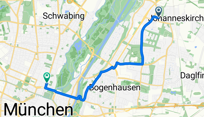
How cycling in Bogenhausen could look like.
How cycling in Munich could look like.

Quick ride by bicycle from Bogenhausen to Munich

Customize your own route based on our template or discover how our community prefers to cycle from Bogenhausen to Munich.

Route template

Bogenhausen to Munich

19 min
Duration
4.6 km
Distance
24 m
Ascent
20 m
Descent
14.4 km/h
Avg. speed
528 m
Max. altitude

Kick off your ride in the charming district of Bogenhausen, an upscale neighborhood known for its elegant architecture and scenic walks along the Isar River. You'll be pedaling just a little over 4.6 kilometers, so it's a perfect short and sweet ride to stretch your legs.

The route is mostly smooth sailing with a mix of asphalt and a few paving stones, so expect an easy ride with gentle slopes having an ascent of roughly 24 meters. It’s quite the relaxed journey with almost half of the way being a dedicated cycle path and quiet roads, making it perfect for enjoying a leisurely cycle without much traffic hassle.

As you head toward the heart of Munich, keep an eye out for the vibrant Stadtmitte area, where historical charm meets modern hustle. Munich itself is a city bursting with culture, boasting everything from beer gardens to art museums, so it’s a great finishing point to explore a little more on foot or grab a hearty Bavarian bite to eat.

Whether you're a local or just visiting, this Bogenhausen to Munich ride is a breezy trip that'll give you just the right mix of exercise and sightseeing!

Community

Top users in this region

From our community

The best bike routes from Bogenhausen to Munich

1

Von der Münchner Freiheit zum Olympiapark

Cycling route in Bogenhausen, Bavaria, Germany

Absolut entspannte Route von der Münchner Freiheit quer durch Schwabing über eine Fahrradstraße, die am Ende direkt in einen gemischten, aber breiten Fußgängerweg übergeht. Dieser mündet am Ackermannbogen in einer Brücke in den Olympiapark hinein auf einen der Hauptwege. Imprinzip immer geradeaus (2 Ampelkreuzungen).
3.8 km
Distance
17 m
Ascent
10 m
Descent
München - Abendrunde 75
Road bikePaved
4

München - Abendrunde 75

Cycling route in Bogenhausen, Bavaria, Germany

76 km
Distance
359 m
Ascent
370 m
Descent
0

Regina-Ullmann-Straße 18, München nach Ludwigstraße 16, München

Cycling route in Bogenhausen, Bavaria, Germany

7.3 km
Distance
13 m
Ascent
13 m
Descent
Isar + Münchner Norden
MTBPavedUnpavedGravel
2

Isar + Münchner Norden

Cycling route in Bogenhausen, Bavaria, Germany

Entlang der Isar raus aus München und im Norden etwas übers Land, bevor es wieder an der Isar entlang zurück geht.
60.3 km
Distance
62 m
Ascent
77 m
Descent
1

Marianne-Brandt-Straße 15, München nach Maximilianstraße 36, München

Cycling route in Bogenhausen, Bavaria, Germany

7.7 km
Distance
99 m
Ascent
91 m
Descent
0

München a la Jan

Cycling route in Bogenhausen, Bavaria, Germany

10.6 km
Distance
92 m
Ascent
74 m
Descent
1

Innstraße 16 - Oskar-von-Miller-Ring 20

Cycling route in Bogenhausen, Bavaria, Germany

<table class="directions-table " border="0" cellspacing="0" cellpadding="0" width="100%"> <tbody> <tr> <td class="directions-line directions-line-first" style="vertical-align: middle;"><img src="images/start.png" alt="" /></td> <td class="directions-line" colspan="2">Innstraße 16, 81679 München, Deutschland</td> </tr> <tr> <td class="directions-line directions-line-first">1.</td> <td class="directions-line">Richtung West auf Innstraße</td> <td class="directions-line directions-line-last">43 m</td> </tr> <tr> <td class="directions-line directions-line-first">2.</td> <td class="directions-line">Bei Ebersberger Straße links abbiegen</td> <td class="directions-line directions-line-last">0.1 km</td> </tr> <tr> <td class="directions-line directions-line-first">3.</td> <td class="directions-line">Bei Röntgenstraße rechts abbiegen</td> <td class="directions-line directions-line-last">9 m</td> </tr> <tr> <td class="directions-line directions-line-first">4.</td> <td class="directions-line">Bei Keplerstraße links abbiegen</td> <td class="directions-line directions-line-last">62 m</td> </tr> <tr> <td class="directions-line directions-line-first">5.</td> <td class="directions-line">Bei Shakespeareplatz rechts abbiegen</td> <td class="directions-line directions-line-last">0.1 km</td> </tr> <tr> <td class="directions-line directions-line-first">6.</td> <td class="directions-line">Bei Possartstraße rechts abbiegen</td> <td class="directions-line directions-line-last">17 m</td> </tr> <tr> <td class="directions-line directions-line-first">7.</td> <td class="directions-line">Bei Cuvilliésstraße links abbiegen</td> <td class="directions-line directions-line-last">0.5 km</td> </tr> <tr> <td class="directions-line directions-line-first">8.</td> <td class="directions-line">Bei Ismaninger Straße links abbiegen</td> <td class="directions-line directions-line-last">68 m</td> </tr> <tr> <td class="directions-line directions-line-first">9.</td> <td class="directions-line">Bei Siebertstraße rechts abbiegen</td> <td class="directions-line directions-line-last">0.3 km</td> </tr> <tr> <td class="directions-line directions-line-first">10.</td> <td class="directions-line">Bei Maria-Theresia-Straße links abbiegen</td> <td class="directions-line directions-line-last">7 m</td> </tr> <tr> <td class="directions-line directions-line-first">11.</td> <td class="directions-line">Rechts abbiegen</td> <td class="directions-line directions-line-last">0.2 km</td> </tr> <tr> <td class="directions-line directions-line-first">12.</td> <td class="directions-line">Bei Wilhelm-Hausenstein-Weg links abbiegen</td> <td class="directions-line directions-line-last">0.1 km</td> </tr> <tr> <td class="directions-line directions-line-first">13.</td> <td class="directions-line">Bei Prinzregentenstraße rechts abbiegen</td> <td class="directions-line directions-line-last">0.2 km</td> </tr> <tr> <td class="directions-line directions-line-first">14.</td> <td class="directions-line">Rechts halten</td> <td class="directions-line directions-line-last">0.1 km</td> </tr> <tr> <td class="directions-line directions-line-first">15.</td> <td class="directions-line">Rechts halten bei Von-der-Tann-Straße</td> <td class="directions-line directions-line-last">1.3 km</td> </tr> <tr> <td class="directions-line directions-line-first">16.</td> <td class="directions-line">Weiter auf Ludwigstraße</td> <td class="directions-line directions-line-last">18 m</td> </tr> <tr> <td class="directions-line directions-line-first">17.</td> <td class="directions-line">Links abbiegen</td> <td class="directions-line directions-line-last">4 m</td> </tr> <tr> <td class="directions-line directions-line-first">18.</td> <td class="directions-line">Bei Oskar-von-Miller-Ring rechts abbiegen</td> <td class="directions-line directions-line-last">0.2 km</td> </tr> <tr> <td class="directions-line directions-line-first">19.</td> <td class="directions-line">Bei Kardinal-Döpfner-Straße links abbiegen</td> <td class="directions-line directions-line-last">19 m</td> </tr> <tr> <td class="directions-line directions-line-first">20.</td> <td class="directions-line">Rechts halten bei Oskar-von-Miller-Ring</td> <td class="directions-line directions-line-last">0.1 km</td> </tr> <tr> <td class="directions-line directions-line-first" style="padding-top: 4px; border: medium none;"><img src="images/stop.png" alt="" /></td> <td class="directions-line" style="border: medium none;" colspan="2">Oskar-von-Miller-Ring 20, 80333 München, Deutschland</td> </tr> </tbody> </table>
3.1 km
Distance
22 m
Ascent
33 m
Descent
0

Mäleßkircherstraße 1 - Oskar-von-Miller-Ring 20

Cycling route in Bogenhausen, Bavaria, Germany

Mäleßkircherstraße 1, 81929 München, Deutschland Richtung Süd auf Mäleßkircherstraße 0.2 km Rechts halten bei Kohlbrennerstraße 0.2 km Rechts halten bei Daglfinger Straße 1.3 km Weiter auf Denninger Straße 2.8 km Links abbiegen 95 m Links halten bei Montgelasstraße 0.8 km Bei Thomas-Mann-Allee rechts abbiegen 5 m Links abbiegen 0.4 km Weiter auf Unterführung 0.2 km Links halten bei Emil-Riedel-Straße 0.2 km Bei Paradiesstraße rechts abbiegen 0.1 km Rechts halten bei Oettingenstraße 23 m Links abbiegen 0.6 km Bei Von-der-Tann-Straße rechts abbiegen 0.9 km Weiter auf Ludwigstraße 18 m Links abbiegen 4 m Bei Oskar-von-Miller-Ring rechts abbiegen 0.2 km Bei Kardinal-Döpfner-Straße links abbiegen 19 m Rechts halten bei Oskar-von-Miller-Ring 0.1 km Oskar-von-Miller-Ring 20, 80333 München, Bundesrepublik Deutschland
7.1 km
Distance
47 m
Ascent
44 m
Descent
0

Langkofelstraße 3 - Oskar-von-Miller-Ring 20

Cycling route in Bogenhausen, Bavaria, Germany

<table class="directions-table " border="0" cellspacing="0" cellpadding="0" width="100%"> <tbody> <tr> <td class="directions-line directions-line-first" style="vertical-align: middle;"><img src="images/start.png" alt="" /></td> <td class="directions-line" colspan="2">Langkofelstraße 3, 81671 München, Deutschland</td> </tr> <tr> <td class="directions-line directions-line-first">1.</td> <td class="directions-line">Richtung Nord auf Langkofelstraße</td> <td class="directions-line directions-line-last">22 m</td> </tr> <tr> <td class="directions-line directions-line-first">2.</td> <td class="directions-line">Weiter</td> <td class="directions-line directions-line-last">1.0 km</td> </tr> <tr> <td class="directions-line directions-line-first">3.</td> <td class="directions-line">Bei Josephsburgstraße links abbiegen</td> <td class="directions-line directions-line-last">9 m</td> </tr> <tr> <td class="directions-line directions-line-first">4.</td> <td class="directions-line">Bei Else-Rosenfeld-Straße rechts abbiegen</td> <td class="directions-line directions-line-last">0.2 km</td> </tr> <tr> <td class="directions-line directions-line-first">5.</td> <td class="directions-line">Bei B304/Kreillerstraße links abbiegen</td> <td class="directions-line directions-line-last">46 m</td> </tr> <tr> <td class="directions-line directions-line-first">6.</td> <td class="directions-line">Rechts abbiegen</td> <td class="directions-line directions-line-last">1.9 km</td> </tr> <tr> <td class="directions-line directions-line-first">7.</td> <td class="directions-line">Rechts halten bei Haidenauplatz</td> <td class="directions-line directions-line-last">13 m</td> </tr> <tr> <td class="directions-line directions-line-first">8.</td> <td class="directions-line">Rechts halten</td> <td class="directions-line directions-line-last">0.9 km</td> </tr> <tr> <td class="directions-line directions-line-first">9.</td> <td class="directions-line">Bei Prinzregentenstraße links abbiegen</td> <td class="directions-line directions-line-last">7 m</td> </tr> <tr> <td class="directions-line directions-line-first">10.</td> <td class="directions-line">Rechts halten</td> <td class="directions-line directions-line-last">0.1 km</td> </tr> <tr> <td class="directions-line directions-line-first">11.</td> <td class="directions-line">Bei Possartstraße rechts abbiegen</td> <td class="directions-line directions-line-last">8 m</td> </tr> <tr> <td class="directions-line directions-line-first">12.</td> <td class="directions-line">Links abbiegen</td> <td class="directions-line directions-line-last">0.6 km</td> </tr> <tr> <td class="directions-line directions-line-first">13.</td> <td class="directions-line">Weiter auf Prinzregentenstraße</td> <td class="directions-line directions-line-last">0.4 km</td> </tr> <tr> <td class="directions-line directions-line-first">14.</td> <td class="directions-line">Rechts halten</td> <td class="directions-line directions-line-last">0.1 km</td> </tr> <tr> <td class="directions-line directions-line-first">15.</td> <td class="directions-line">Rechts halten bei Von-der-Tann-Straße</td> <td class="directions-line directions-line-last">1.3 km</td> </tr> <tr> <td class="directions-line directions-line-first">16.</td> <td class="directions-line">Weiter auf Ludwigstraße</td> <td class="directions-line directions-line-last">18 m</td> </tr> <tr> <td class="directions-line directions-line-first">17.</td> <td class="directions-line">Links abbiegen</td> <td class="directions-line directions-line-last">4 m</td> </tr> <tr> <td class="directions-line directions-line-first">18.</td> <td class="directions-line">Bei Oskar-von-Miller-Ring rechts abbiegen</td> <td class="directions-line directions-line-last">0.2 km</td> </tr> <tr> <td class="directions-line directions-line-first">19.</td> <td class="directions-line">Bei Kardinal-Döpfner-Straße links abbiegen</td> <td class="directions-line directions-line-last">19 m</td> </tr> <tr> <td class="directions-line directions-line-first">20.</td> <td class="directions-line">Rechts halten bei Oskar-von-Miller-Ring</td> <td class="directions-line directions-line-last">0.1 km</td> </tr> <tr> <td class="directions-line directions-line-first" style="padding-top: 4px; border: medium none;"><img src="images/stop.png" alt="" /></td> <td class="directions-line" style="border: medium none;" colspan="2">Oskar-von-Miller-Ring 20, 80333 München, Bundesrepublik Deutschland</td> </tr> </tbody> </table>
6.4 km
Distance
39 m
Ascent
49 m
Descent
0

Munich to Bolzano

Cycling route in Bogenhausen, Bavaria, Germany

2024 Munich and back
1,209 km
Distance
14,751 m
Ascent
14,762 m
Descent
0

Hans-Denzinger-Straße 13 - Oskar-von-Miller-Ring 20

Cycling route in Bogenhausen, Bavaria, Germany

<table class="directions-table " border="0" cellspacing="0" cellpadding="0" width="100%"> <tbody> <tr> <td class="directions-line directions-line-first" style="vertical-align: middle;"><img src="images/start.png" alt="" /></td> <td class="directions-line" colspan="2">Hans-Denzinger-Straße 13, 80807 München, Deutschland</td> </tr> <tr> <td class="directions-line directions-line-first">1.</td> <td class="directions-line">Richtung Ost auf Hans-Denzinger-Straße</td> <td class="directions-line directions-line-last">0.2 km</td> </tr> <tr> <td class="directions-line directions-line-first">2.</td> <td class="directions-line">Bei Torquato-Tasso-Straße rechts abbiegen</td> <td class="directions-line directions-line-last">0.1 km</td> </tr> <tr> <td class="directions-line directions-line-first">3.</td> <td class="directions-line">Bei Christoph-Schmid-Straße links abbiegen</td> <td class="directions-line directions-line-last">0.3 km</td> </tr> <tr> <td class="directions-line directions-line-first">4.</td> <td class="directions-line">Bei Eduard-Schenk-Straße rechts abbiegen</td> <td class="directions-line directions-line-last">0.2 km</td> </tr> <tr> <td class="directions-line directions-line-first">5.</td> <td class="directions-line">Links abbiegen</td> <td class="directions-line directions-line-last">3.8 km</td> </tr> <tr> <td class="directions-line directions-line-first">6.</td> <td class="directions-line">Bei Oskar-von-Miller-Ring rechts abbiegen</td> <td class="directions-line directions-line-last">0.2 km</td> </tr> <tr> <td class="directions-line directions-line-first">7.</td> <td class="directions-line">Bei Kardinal-Döpfner-Straße links abbiegen</td> <td class="directions-line directions-line-last">19 m</td> </tr> <tr> <td class="directions-line directions-line-first">8.</td> <td class="directions-line">Rechts halten bei Oskar-von-Miller-Ring</td> <td class="directions-line directions-line-last">0.1 km</td> </tr> <tr> <td class="directions-line directions-line-first" style="padding-top: 4px; border: medium none;"><img src="images/stop.png" alt="" /></td> <td class="directions-line" style="border: medium none;" colspan="2">Oskar-von-Miller-Ring 20, 80333 München, Bundesrepublik Deutschland</td> </tr> </tbody> </table>
4.8 km
Distance
29 m
Ascent
16 m
Descent
bv cjcjccbmvcbmc
PavedUnpaved
0

bv cjcjccbmvcbmc

Cycling route in Bogenhausen, Bavaria, Germany

 nb b
10.7 km
Distance
12 m
Ascent
8 m
Descent

Discover more routes