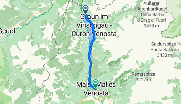
By bicycle from Graun im Vinschgau to Mals
Customize your own route based on our template or discover how our community prefers to cycle from Graun im Vinschgau to Mals.
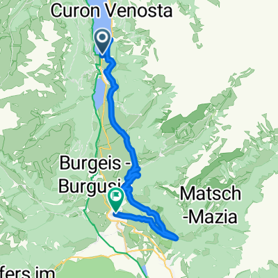
Route template
Graun im Vinschgau to Mals

- 1 h 4 min
- Duration
- 17.8 km
- Distance
- 230 m
- Ascent
- 727 m
- Descent
- 16.6 km/h
- Avg. speed
- 1,533 m
- Max. altitude
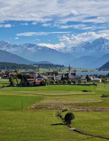
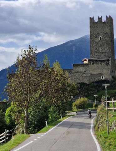
This ride kicks off in Graun im Vinschgau, famous for its hauntingly beautiful submerged bell tower rising out of Lake Reschen—a must-stop for a photo! From here, you’ll head south toward Mals, winding through 17.8 km of mostly paved roads and quiet tracks. The route serves up a good bit of descent—over 700 meters of it—so you can really enjoy cruising down through the scenic South Tyrolean landscape.
Expect breathtaking alpine views as you pass rolling fields and mountain backdrops. With most surfaces being smooth asphalt, you’ll only encounter occasional gravel patches, perfect for keeping things interesting but nothing too technical.
Your ride finishes in Mals, a charming town at the foot of the Ortler Alps, renowned for its Romanesque church towers and laid-back vibe. Treat yourself to a coffee or gelato at one of the local cafes—you’ve earned it! It’s a lovely ride, with just enough climb at the start to justify the sweeping descent into the heart of the Vinschgau Valley.
Bikepacking tours
Already sliced up into perfect stages by our community
Community
Top users in this region


From our community
The best bike routes from Graun im Vinschgau to Mals
6 July from Reschebsee to Nalles Venosta
Cycling route in Graun im Vinschgau, Trentino-Alto Adige, Italy
- 19.4 km
- Distance
- 229 m
- Ascent
- 709 m
- Descent

6 Goasberg-Cross
Cycling route in Graun im Vinschgau, Trentino-Alto Adige, Italy
- 17.2 km
- Distance
- 808 m
- Ascent
- 1,085 m
- Descent

Obervinschger Panoramatour
Cycling route in Graun im Vinschgau, Trentino-Alto Adige, Italy
- 20.8 km
- Distance
- 420 m
- Ascent
- 917 m
- Descent

Reschen - Sesvenna Hütte
Cycling route in Graun im Vinschgau, Trentino-Alto Adige, Italy
- 28.4 km
- Distance
- 1,079 m
- Ascent
- 338 m
- Descent

MTB-Tour: Obervinschgauer Panoramatour
Cycling route in Graun im Vinschgau, Trentino-Alto Adige, Italy
- 22.6 km
- Distance
- 412 m
- Ascent
- 842 m
- Descent

1. Etappe nach Mals
Cycling route in Graun im Vinschgau, Trentino-Alto Adige, Italy
- 19.8 km
- Distance
- 112 m
- Ascent
- 552 m
- Descent

Curon Venosta a Via di Burgusio, Malles Venosta
Cycling route in Graun im Vinschgau, Trentino-Alto Adige, Italy
- 18.1 km
- Distance
- 682 m
- Ascent
- 981 m
- Descent

Planeil
Cycling route in Graun im Vinschgau, Trentino-Alto Adige, Italy
- 23.7 km
- Distance
- 898 m
- Ascent
- 1,122 m
- Descent

Reschen bis Quellenhof
Cycling route in Graun im Vinschgau, Trentino-Alto Adige, Italy
- 21.7 km
- Distance
- 291 m
- Ascent
- 717 m
- Descent

Sesvennahütte
Cycling route in Graun im Vinschgau, Trentino-Alto Adige, Italy
- 25.2 km
- Distance
- 1,110 m
- Ascent
- 348 m
- Descent

stelvio 1
Cycling route in Graun im Vinschgau, Trentino-Alto Adige, Italy
- 84.4 km
- Distance
- 1,863 m
- Ascent
- 2,423 m
- Descent
Fimberpass – Val d'Uina – Reschenpass Etappe 3: Graun im Vinschgau – Mals
Cycling route in Graun im Vinschgau, Trentino-Alto Adige, Italy
- 10.9 km
- Distance
- 139 m
- Ascent
- 716 m
- Descent
Discover more routes
 MTB-Tour: Obervinschgauer Panoramatour
- Distance
- 22.6 km
- Ascent
- 412 m
- Descent
- 842 m
- Location
- Graun im Vinschgau, Trentino-Alto Adige, Italy
 1. Etappe nach Mals
- Distance
- 19.8 km
- Ascent
- 112 m
- Descent
- 552 m
- Location
- Graun im Vinschgau, Trentino-Alto Adige, Italy
 Curon Venosta a Via di Burgusio, Malles Venosta
- Distance
- 18.1 km
- Ascent
- 682 m
- Descent
- 981 m
- Location
- Graun im Vinschgau, Trentino-Alto Adige, Italy
 Planeil
- Distance
- 23.7 km
- Ascent
- 898 m
- Descent
- 1,122 m
- Location
- Graun im Vinschgau, Trentino-Alto Adige, Italy
 Reschen bis Quellenhof
- Distance
- 21.7 km
- Ascent
- 291 m
- Descent
- 717 m
- Location
- Graun im Vinschgau, Trentino-Alto Adige, Italy
 Sesvennahütte
- Distance
- 25.2 km
- Ascent
- 1,110 m
- Descent
- 348 m
- Location
- Graun im Vinschgau, Trentino-Alto Adige, Italy
 stelvio 1
- Distance
- 84.4 km
- Ascent
- 1,863 m
- Descent
- 2,423 m
- Location
- Graun im Vinschgau, Trentino-Alto Adige, Italy
 Fimberpass – Val d'Uina – Reschenpass Etappe 3: Graun im Vinschgau – Mals
- Distance
- 10.9 km
- Ascent
- 139 m
- Descent
- 716 m
- Location
- Graun im Vinschgau, Trentino-Alto Adige, Italy
Routes from Graun im Vinschgau
Bikepacking from
Graun im Vinschgau to Trento
Cycling day trip from
Graun im Vinschgau to Naturns
Cycling day trip from
Graun im Vinschgau to Merano
Routes to Mals
Bikepacking from
Landeck to Mals
Cycling day trip from
Nauders to Mals
Cycling day trip from
Pfunds to Mals